Seismic tomography scans have huge potential in the geography classroom. But what are they? In simple terms, they are like a CAT scan of the interior of the Earth. They are created by measuring the speed of seismic waves. Areas, where there is a low velocity, correspond with hotter, less dense zones in the mantle (e.g. a mantle plume). To find out more about seismic tomography scans take a look at this excellent guide by Earth Scope.
There are a number of tools available to generate seismic tomography scans. Our favourite is the Hades Underworld Explorer. The interface is made to facilitate the discovery and visualisation of mantle anomalies. A tomographic model can be generated by either selecting a section preset or by dragging markers to generate a cross-section of the mantle.
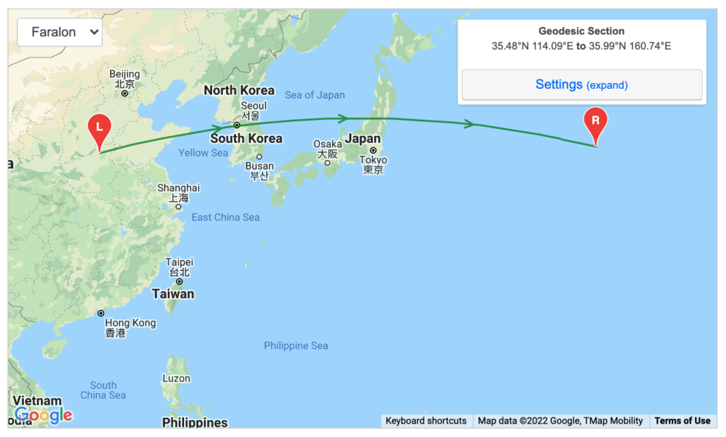
In the example below, a selection has been made in the northwest Pacific, in Asia.
A selection in the north-west Pacific
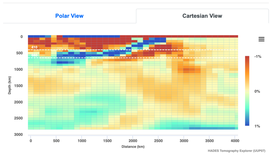
The website then generates a tomography scan showing the cross-section of the mantle.
The subduction of the Eurasian plate by the Pacific Plate
The depth of the mantle is shown in kilometres on the x-axis. The key shows velocity anomalies. In the case of the tomography scan above the colder, more dense material is shown in blue, while the hotter, less dense material is shown in red. Based on this we can see the destructive margin formed by the Eurasian plate being subducted by the Pacific plate. The Pacific Plate sinking into the mantle as illustrated by the cooler crust (shaded blue), reaches a depth of around 800 km.
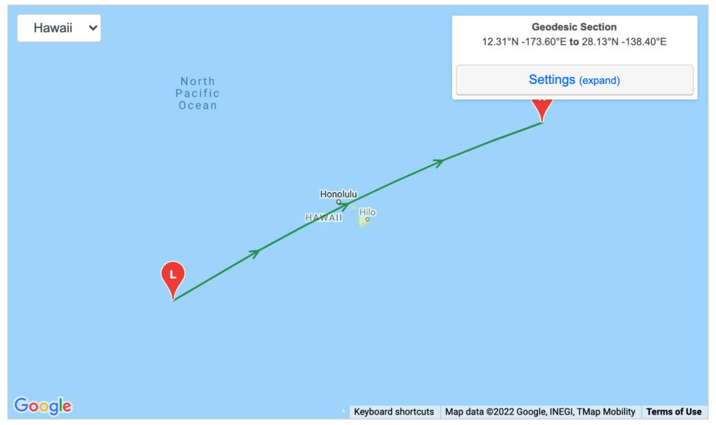
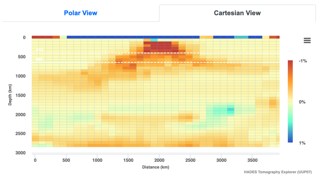
In the example below the mantle plume at Hawaii is clearly visible (accessed via the drop-down menu).
Hawaii
Hawaii mantle plume
Tomography scans lack the resolution required to image plumes deep within the mantle.
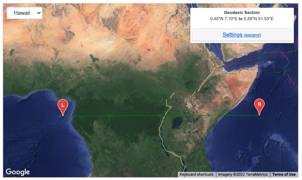
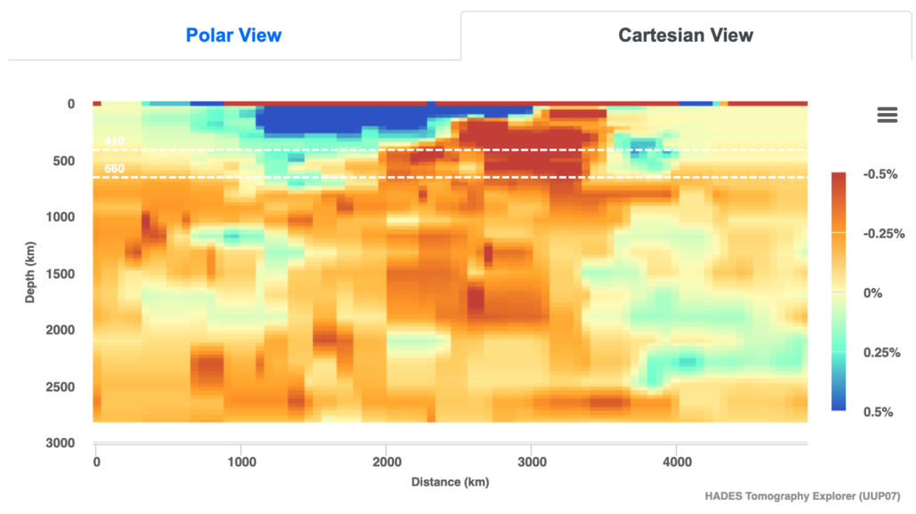
The tomography scan below illustrates the Rift Valley in eastern Africa.
Rift valley transect
Rift valley tomography scan
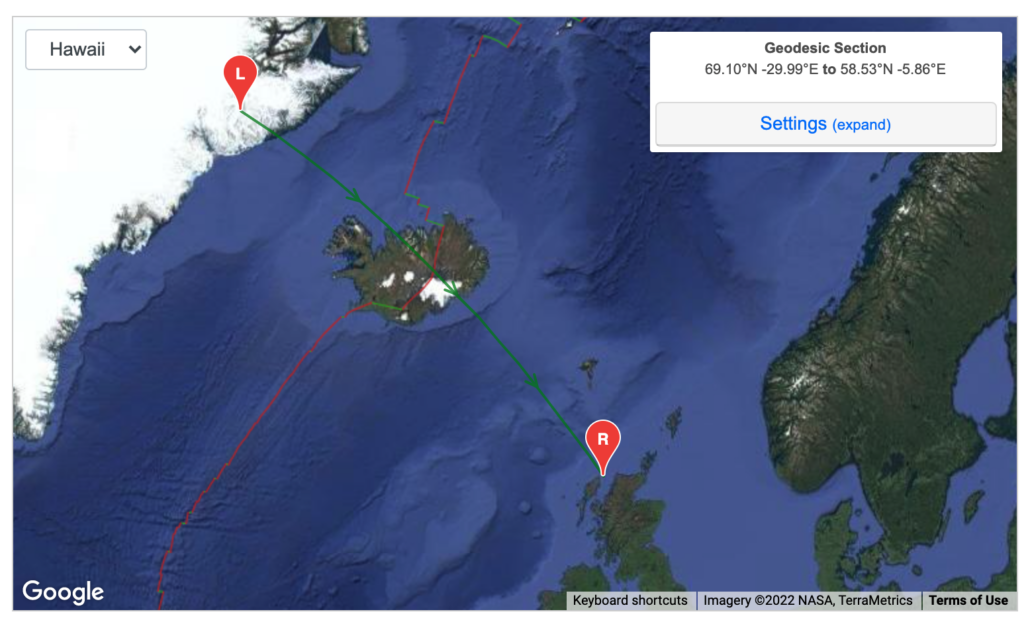
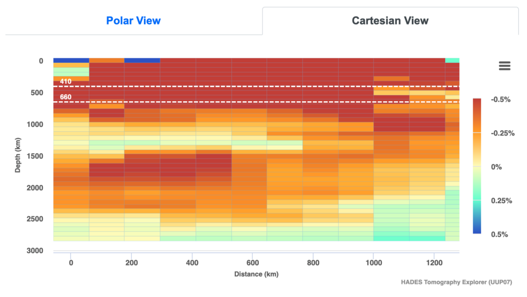
The tomography scan below shows the Northern Atlantic.
North Atlantic Transect
North Atlantic Tomography scan
In the tomography scan above we can see that the conduit spreads laterally across the North Atlantic, to a depth of around 900 km. There is a conduit feeding this between 900-1200 km along the transect at a depth of around 1000 – 1500 km.
Alistair Hamill has shared a number of resources on the use of seismic tomography on Twitter and inspired our interest in this area. Below are a selection of tweets by Alistair that are well worth exploring.
I think that tomography scans of the mantle are a great way to teach our A Level geographers our latest understanding of the processes down there. If tomography is new to you, check out this annotated scan of the Iceland mantle plume for a sense of what it can reveal. pic.twitter.com/RYzzEkox0M
1/ My Y13s had their first explore of seismic tomography today, using Atlas of the Underworld to draw a series of cross sections through the mantle to find evidence of subducting plates. I've been so looking forward to doing this with them – and they nailed it!!
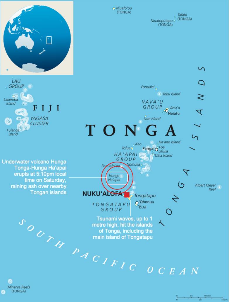
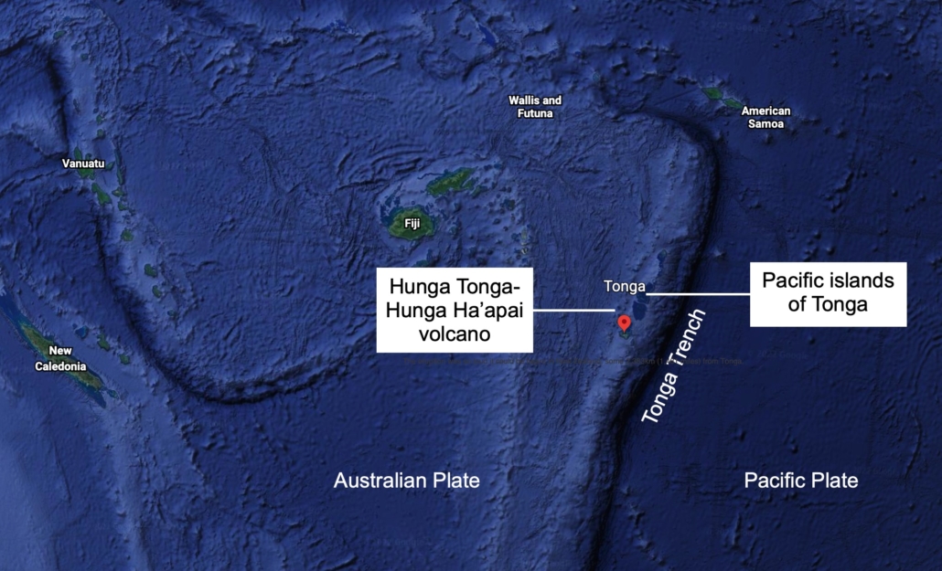
The Hunga Tonga-Hunga Ha’apai volcano is located in the South Pacific, around 65km (40 miles) north of Tonga’s capital, Nuku’alofa. The volcano is part of an arc of volcanic islands known as the Tonga-Kermadec Islands volcanic arc and forms part of the Pacific Ring of Fire.
The location of the Hunga Tonga-Hunga Ha’apai volcano
What was the volcano like before it erupted?
Before its eruption, the Hunga Tonga-Hunga Ha’apai volcano was 1.8km high and 20km wide. However, the volcano was only 114 metres above sea level at its highest point. The video below illustrates the majority of the volcano is undersea (shared by A Hamill).
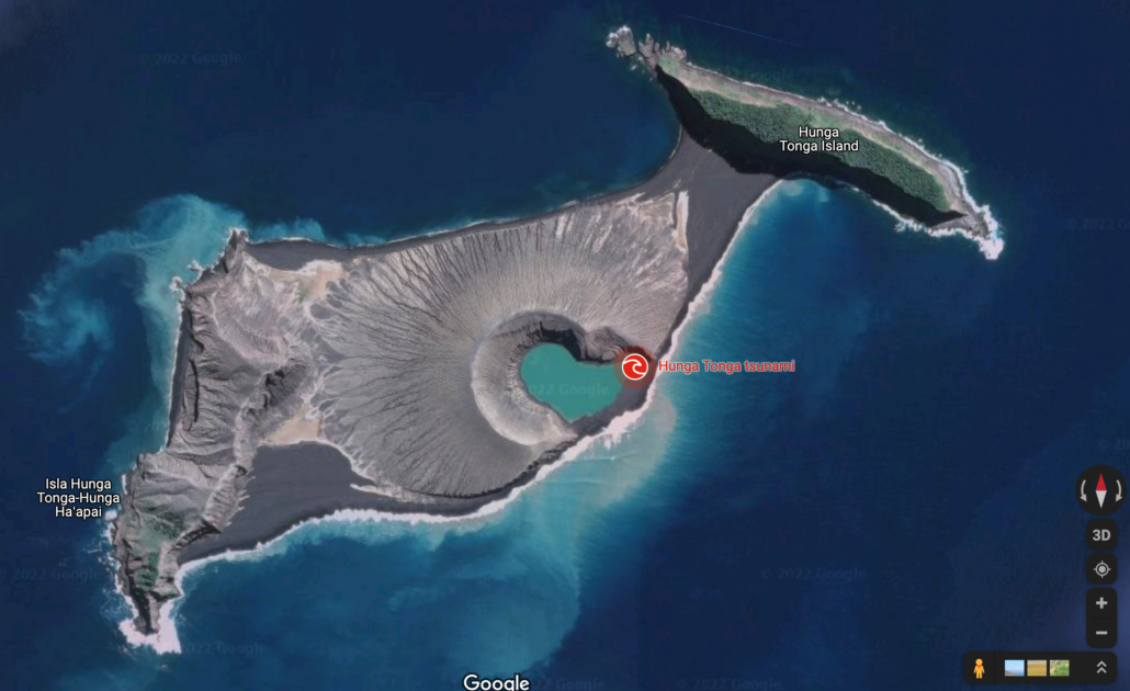
Volcanic activity in 2009 joined the islands of Hunga Tonga and Hunga Ha’apai, which were themselves produced by older volcanic eruptions.
The satellite image above was taken before the eruption of the Hunga Tonga-Hunga Ha’apai volcano.
Recent activity of the Hunga Tonga-Hunga Ha’apai volcano
The volcano became active on 20th December 2021. However, it was declared dormant by the Tonga Geological Service on 11th January 2022.
At around 4.20 am local time on 14th January 2022 (3.10 pm GMT on 13th January 2022), the Hunga Tonga-Hunga Ha’apai volcano erupted, sending plumes of ash, steam and gas up to 20km into the atmosphere.
The video below shows the eruption of the Hunga Tonga-Hunga Ha’apai volcano on 14th January 2022.
The images below show the volcano on 7th January 2022 then again after the eruption on the 13th January 2022. The satellite images after the eruption show that the connecting volcanic cone has been largely destroyed.
What was the main eruption like?
The eruption on 13th January was followed by a more significant, more explosive event at 5.15 pm local time on 15th January. The explosion generated enormous energy and created an umbrella cloud of ash, spreading the plume concentrically outwards instead of being dispersed in one direction by the wind. It was the most powerful eruption of the volcano since 1100 AD. The eruption was so loud it could be heard in New Zealand, some 2,383km (1,481 miles) from Tonga.
The initial height of the ash plume is an estimated 15.2km in altitude, later rising up to 30km high. The plume then spread to 260km in diameter before being distorted by wind. The graphic below provides a sense of the scale of the eruption.
The scale of the eruption of Hunga Tonga-Hunga Ha’apai volcano
Why did the eruption occur?
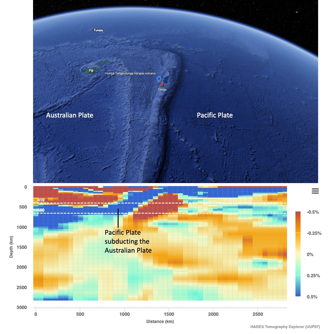
Tonga’s volcanic islands are located on a destructive plate margin where the Pacific Plate meets the Australian Plate.
Tonga’s Tectonic Setting
The seismic tomography scan of the mantle below shows the Pacific Plate subducting below the Australian Plate. The water brought down by the slab is forced into the mantle above, producing the magma which forms the volcanic islands.
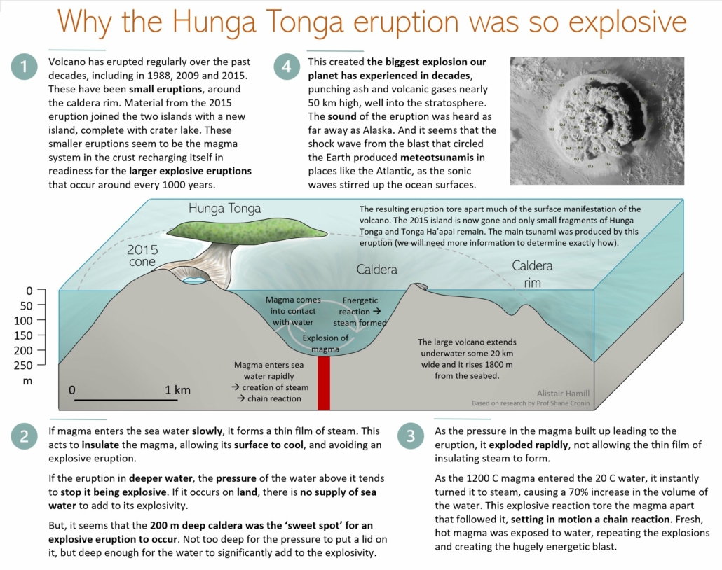
The graphic below provides an overview of why the eruption could have been so powerful.
Why was the eruption of The Hunga Tonga-Hunga Ha’apai volcano so powerful? Source: Alistair Hamill, reproduced under a CC 3.0 licence with kind permission.
What were the effects of the eruption?
Following the eruption, people fled their homes and streets, and buildings flooded as tsunami waves crashed into Tonga’s main island of Tongatapu.
Twenty minutes after the eruption, a 1.2-metre tsunami wave is observed at Nuku’alofa, Tonga’s capital, according to the Australian Bureau of Meteorology. Waves reaching up to 15 metres (49 feet) hit the outer Ha’apia island group, destroying all the houses on the island of Mango, as well as the west coast of Tonga’s main island, Tongatapu, where 56 houses were destroyed or seriously damaged, the prime minister’s office said. People were evacuated from these islands.
Tsunami videos out of Tonga 🇹🇴 this afternoon following the Volcano Eruption. pic.twitter.com/JTIcEdbpGe
Photos and videos emerged on social media of large waves flooding coastal areas, with reports of people making their way inland and to higher ground. Footage shows waves causing damage to buildings and infrastructure such as seawalls.
Experts believe the tsunami activity could have been triggered either by shock waves propagating through water or by a landslide on the undersea part of the volcano. The cause is currently unknown and may rely on sea bed monitoring to identify the cause.
A convoy of police and military troops evacuated King Tupou VI from his palace near the shore, and local news site Kaniva Tonga reported long lines of traffic as thousands of people attempted to reach higher ground across the main island.
By evening in the Pacific, the volcano is raining ash and tiny pebbles on neighbouring Tongan islands, with reports of darkness blanketing the sky.
Nuku’alofa was covered in a thick film of volcanic dust. As a result, there were concerns about contamination of food and water supplies and acid rain.
In addition to preventing aircraft from flying, ash hampers recovery efforts because it “buries gardens and impacts plants with consequences for food supply, and is likely to contaminate water supplies,” volcanologist Dr Chris Firth says.
The Pacific nation’s main undersea communication cable linking Tonga to Fiji was damaged. Unfortunately, it may be weeks before the cable can be repaired due to difficulty getting the repair ship from Papua New Guinea to Tonga and safety concerns for the ship’s crew, who would be operating in waters not far from the volcano. As a result, Tongans around the world may be forced to wait weeks for regular contact to resume.
An air pressure surge from the volcano’s eruption was recorded at seismic stations internationally, including in New Zealand, Australia, the US, and the UK, where two shockwaves are observed.
Aerial photographs were taken onboard a monitoring flight by the New Zealand defence force on Monday 17th January show some areas blanketed with ash, with damaged buildings, while others show parts of the country that appear unscathed.
In the hours following the eruption, tsunami warnings were issued across the Pacific, including in New Zealand, Australia, the west coast of the US, and Japan, where around 230,000 people across eight prefectures were ordered to evacuate.
The United Nations said that about 84,000 people, more than 80% of the population, had been badly affected by the disaster. “They have been affected through loss of houses, loss of communication, what we understand is the issue with the water,” UN spokesperson Stephane Dujarric told reporters. “Water is really the biggest life-saving issue. Water sources have been polluted, water systems are down.”
What were the immediate responses to the eruption?
The Fijian government issued a tsunami warning, telling people in coastal parts to move to higher ground due to “larger than usual waves”. There were reports that some Fijian villages were inundated with water and families evacuated.
In Australia, Japan, Hawaii, Alaska and along the US Pacific coast, residents were asked to move away from the coastline to higher ground and pay attention to specific instructions from their local emergency management officials, said Dave Snider, tsunami warning coordinator for the National Tsunami Warning Center in Palmer, Alaska.
Australia’s Bureau of Meteorology issued an evacuation order for Lord Howe Island and warnings for a huge stretch of the mainland’s east coast. Sydney’s Bondi Beach was evacuated overnight, and a marine threat warning remained in place on Sunday morning Australian time.
The Australian defence force sent a surveillance plane on Monday 17th January 2022 to assess damage to critical infrastructure such as roads, ports and power lines.
There was little damage to the Fua’amotu International Airport’s south-eastern runway, but it was unserviceable following the eruption due to ash covering the runway. An operation to clear ash from the runway was underway, with vehicles and people visible from monitoring aircraft flown by New Zealand’s defence force. After the ash descended on Tonga, young men from villages surrounding the capital travelled to the airport to manually clear runways in order to make way for foreign aid planes
Australia and New Zealand pledged $1m in initial aid to Tonga. In addition, New Zealand dispatched two naval ships carrying water and other aid supplies.
The HMNZS Wellington arrived on Thursday 20th January to survey the harbour to ensure its safety ahead of the arrival of the larger HMNZS Aotearoa on Friday, which is carrying supplies including 250,000 litres of water and a desalination plant.
Australia sent an air force plane that also arrived on Thursday 20th January loaded with essential supplies, including protective equipment and shelter materials. The government said it expected to send a naval vessel loaded with equipment, including helicopters, later on, Thursday or Friday.
On 20th January January 2022, a state of emergency was declared in the country until 13th February, the Tongan government announced.
Telephone links between Tonga and the rest of the world were also partially restored on Thursday 20th January, though restoring full internet connectivity is likely to take a month or more, according to the owner of the archipelago’s sole subsea communications cable. The country re-established some connections with the help of 2G internet and satellite telephone links.
Isolated communities on Tonga’s islands had to fend for themselves in the immediate aftermath of the eruption and tsunami.
What were the long-term responses to the eruption?
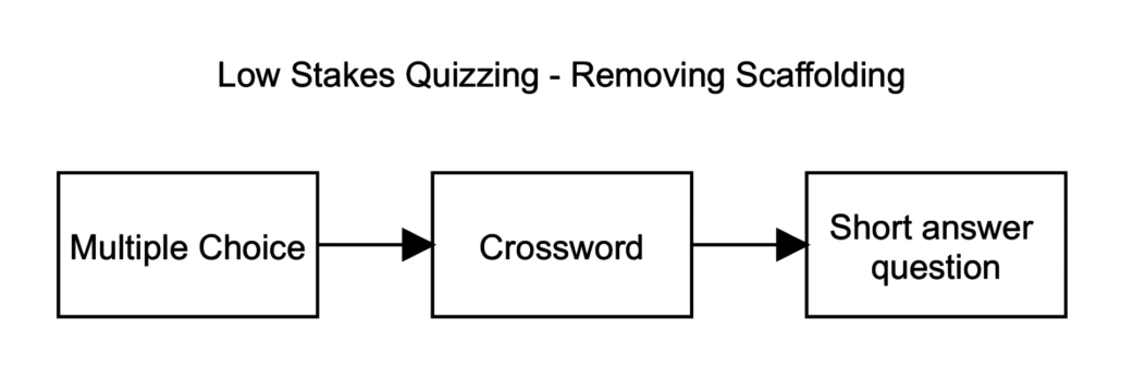
I’ve been thinking quite a lot recently about reducing scaffolding when using retrieval practice strategies. Multiple-choice questions are one of the most commonly used retrieval practice techniques; however, as discussed in the recent blog post, they have limitations – namely, they always include a correct answer. This is not to say they don’t have a use in retrieval practice. However, we should be aiming for students to complete short-answer questions for retrieval practice as they are required to produce the answer.
So, how can we achieve this? One possible approach might be to use multiple-choice questions in the first stage of retrieval practice. These could be used as starter activities or for homework. Once students demonstrate success using multiple-choice questions, the scaffolding could be reduced by providing students with short answer questions in the form of a crossword. Using a crossword, students can complete the questions in any order they like and, for those they find more challenging, the addition of letters from other words can prompt and support them in answering.
Removing Scaffolding
The final step is the introduction of short answer questions. If students continue to need support, the first letter of each answer could be provided. This can then be removed later.
To support geography teachers in reducing scaffolding for retrieval practice, a range of new resources are being developed for subscribers to Internet Geography Plus. We are creating a bank of resources in the form of multiple-choice questions, crosswords and short answer quizzes, each of which is available as an electronic document and interactive resource.
Internet Geography Plus subscribers already have access to a significant bank of multiple-choice questions in MS Word format and fully-customisable MS Forms and Google Forms Quizzes. In addition, we are currently working on crosswords and short answer quizzes.