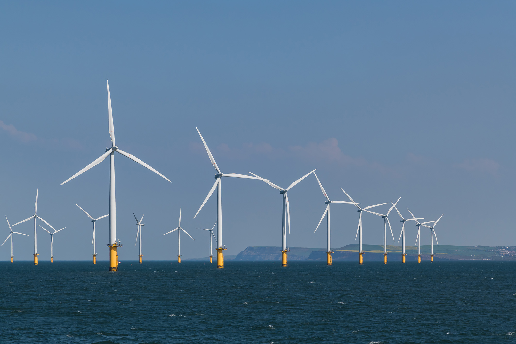
Wind-generated a record amount of electricity in 2022
In 2022, Great Britain generated a record amount of electricity from renewable and nuclear sources, exceeding the amount produced from fossil fuels such as gas and coal. This marks the second-highest level of renewable electricity generation after 2020. The switch to green power is a crucial way to combat the negative effects of climate change.
Renewable energy sources like wind and solar are also becoming increasingly cost-effective, which could result in lower electricity bills over time. While gas remained the primary source of electricity in 2022, according to the National Grid Electricity System Operator (ESO), electricity from wind turbines increased in importance. Overall, 48.5% of electricity in Great Britain came from renewable and nuclear sources, while 40% came from gas and coal.
On a single day in November, wind power produced more than 70% of electricity, or around 20GW. This energy is sufficient to heat approximately 1700 homes a year. The record was broken again on December 30th, when wind turbines generated 20.918GW of electricity.
During five months (February, May, October, November and December), more than half of electricity came from zero-carbon renewable and nuclear sources. The use of coal, the most polluting fossil fuel, also declined, accounting for only 1.5% of electricity in 2022 compared to 43% in 2012.
Despite the increased capacity for renewable energy, the 2015 ban on onshore wind has limited the country’s capacity to increase wind power faster. In December 2022, Prime Minister Rishi Sunak agreed to relax restrictions that effectively prevent onshore wind turbines.
Despite concerns about climate change, the UK approved the first new coal mine in 30 years and opened a new licensing round for companies to explore oil and gas in the North Sea.
The impact of Russia’s war in Ukraine on energy supplies and pricing, as well as sanctions imposed on Russia, a major supplier of gas to Europe, also affected nations like Germany, Spain, Italy, and the US, leading to an increase in renewable capacity.
https://www.internetgeography.net/wp-content/uploads/2023/01/Offshore-Wind-Farm-in-the-UK.jpg13332000Anthony Bennetthttps://www.internetgeography.net/wp-content/uploads/2024/01/Internet-Geography-Logo.pngAnthony Bennett2023-01-08 15:34:392023-01-10 14:07:56Wind generated a record amount of electricity in 2022
https://www.internetgeography.net/wp-content/uploads/2022/11/Japans-Ageing-Population.jpg13332000Anthony Bennetthttps://www.internetgeography.net/wp-content/uploads/2024/01/Internet-Geography-Logo.pngAnthony Bennett2022-11-19 18:08:382022-11-24 01:28:12Beyond 8 Billion – The Ageing Population Crisis in Japan
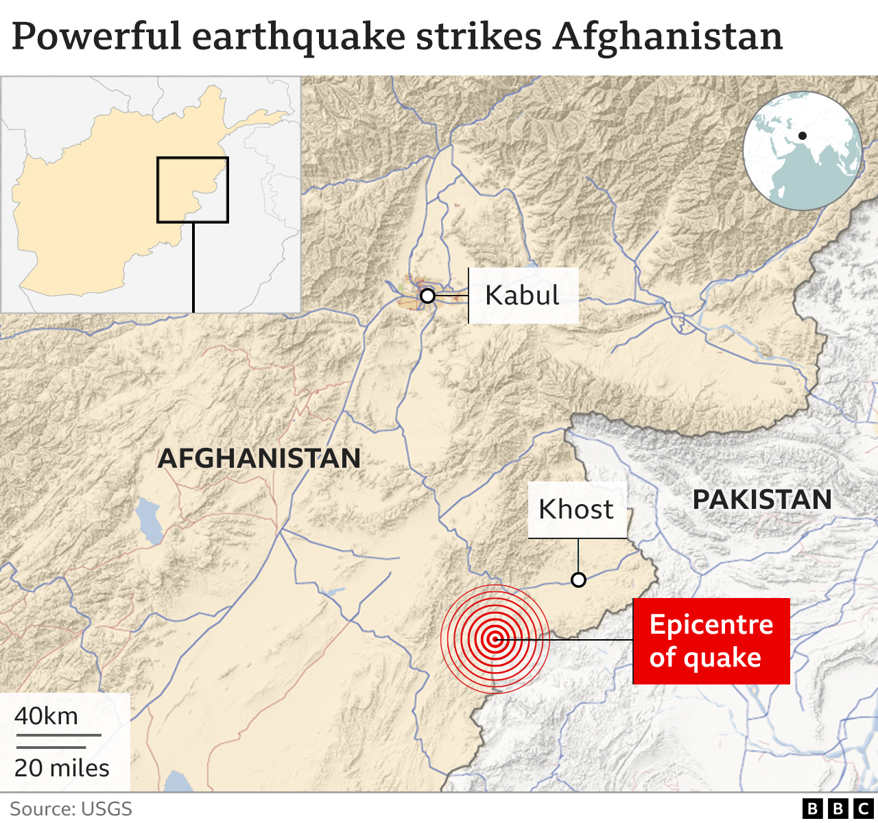
At least 1,036 people have died, and another 2,949 were injured in an earthquake that struck Afghanistan’s Paktika province on the morning of Wednesday 22nd June 2022. The earthquake struck about 44km (27 miles) from the south-eastern city of Khost shortly after 01:30 local time (21:00 Tuesday GMT), when many people were asleep at home.
Earthquakes are common in Afghanistan’s mountainous province of Khost — nearly 50 have been recorded over the past five years, according to the US Geological Survey.
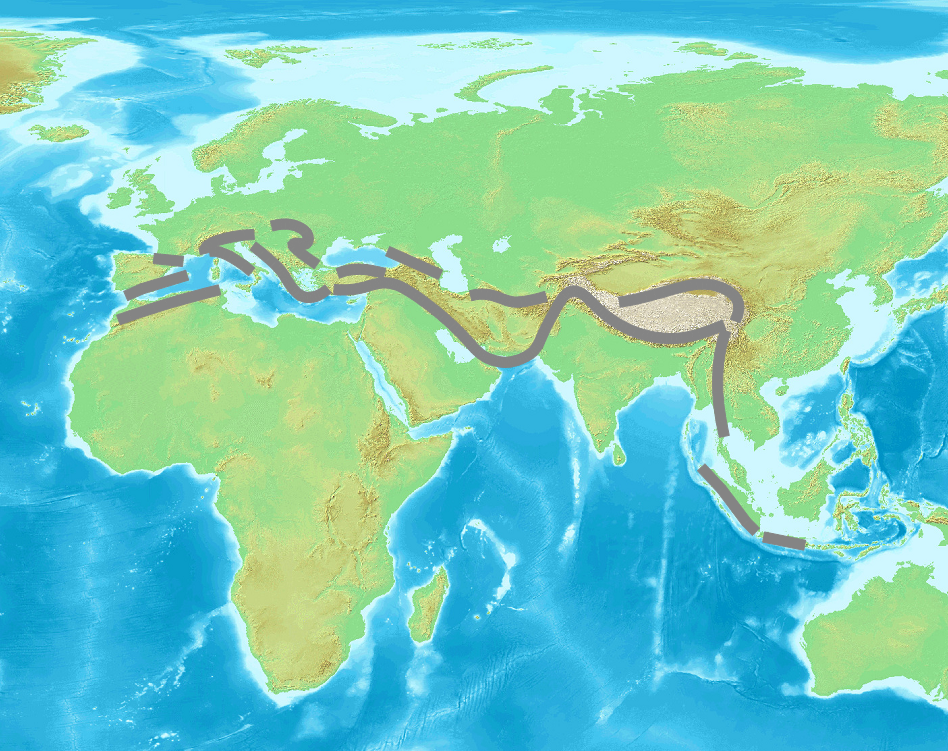
Afghanistan is earthquake-prone because it is located on the Alpide belt, the second most seismically active region in the world after the Pacific Ring of Fire.
The Alpide Belt
The Alpide belt runs about 15,000 kilometres, from the southern part of Eurasia through the Himalayas and into the Atlantic. Along with the Hindu Kush, it includes a number of fold mountain ranges, such as the Alps, Atlas Mountains and the Caucasus Mountains. It has been formed by the collision of a number of tectonic plates.
The Arabian, Indian and Eurasian tectonic plates meet In Afghanistan and create earthquakes when they shift against each other at their borders. The boundary between the Indian and Eurasian plates exists near Afghanistan’s border with Pakistan.
The earthquake in Afghanistan formed when the Indian plate crashed violently with the Eurasian plate. Collisions like this shake and squeeze the ground upwards. Along with causing earthquakes, this movement creates mountains like the Himalayas or the Hindu Kush and Pamir mountain ranges in northeast Afghanistan.
What were the effects of the Afghanistan earthquake?
The most recent figures put the death toll at 1,150 people with at least 1,600 injuries. The number of dead and injured is expected to rise as remote areas are reached and rescue workers are able to search collapsed buildings.
The earthquake destroyed critical infrastructure — including homes, health facilities, schools and water networks.
In the areas that have been accessed so far, as many as 1,900 homes have been destroyed including 1,028 in Giyan, 450 in Barmal and 416 in Spera. Many homes had large families of seven or more people, so the number of people affected is significant. This is well over half of Giyan’s housing stock.
As many as 10,000 more homes have been damaged extensively and risk imminent collapse. Many of the homes were comprised of mud bricks, making them very susceptible to damage and destruction. Ongoing assessments of the conditions of the housing are continuing.
At least 65 children have been orphaned or are unaccompanied in the aftermath of the earthquake.
Of the deaths, at least 155 were children, including 134 in the Giyan district, and 250 were injured. Seven schools in Khost and Paktika provinces were damaged by the earthquake (5,135 students) with additional damage reported in Gani Khil and Dor Baba districts.
The risk of communicable diseases, such as acute watery diarrhoea (AWD)/cholera, and malaria increased due to the fragile living conditions in the affected communities and high temperatures in summer. There was an upward trend of AWD cases following the earthquake (Between 3 to 10 July, a total of 464 AWD cases were reported).
What were the responses to the Afghanistan earthquake?
Since the take over of government by the Taliban in 2021, Afghanistan has experienced a humanitarian crisis, especially since many countries cut diplomatic ties with the country. The new regime has struggled to get to grips with food shortages and a flailing economy. More than a third of people cannot meet their basic needs, women’s rights have been restricted and foreign aid has evaporated.
Dr Orzala Nemat, an Afghan researcher and human rights activist based in the UK, fears that the response could quickly become chaotic without “systematic governance” structures in place since the Taliban takeover.
In a rare move, the Taliban’s supreme leader, Haibatullah Akhundzadah, who almost never appears in public, pleaded with the international community and humanitarian organisations “to help the Afghan people affected by this great tragedy and to spare no effort”.
Afghanistan’s Taliban rulers pledged not to interfere with international efforts to distribute aid to tens of thousands of people affected by the earthquake.
Humanitarian aid has continued, with international agencies, such as the United Nations, operating.
The UN Office for the Coordination of Humanitarian Affairs (UNOCHA) said Afghanistan had asked humanitarian agencies to help with rescue efforts, and teams were being sent to the quake-hit area.
Afghanistan military provided support in search and rescue operations.
International Aid
Japan, South Korea, Taiwan and the United Arab Emirates all offered to send aid. Supplies from neighbouring Pakistan crossed the border.
On July 12, the Government of Japan decided to extend Emergency Grant Aid of 3 million US dollars to Afghanistan in response to the damages caused by the earthquake that had occurred in eastern Afghanistan on June 22. The Government of Japan offered to provide assistance in areas such as health and medical care, shelter, and water and sanitation through the International Federation of Red Cross and Red Crescent Societies (IFRC) to the Afghan people affected by the devastating earthquake.
Non-Government Organisations (NGOs)
The World Health Organisation’s polio team was on the ground joining forces with UN agencies and NGOs to ensure an effective and coordinated relief effort. The team’s invaluable experience and local knowledge gained from more than 2 decades working among local communities in both Paktika and Khost provided the foundations of an assessment tool to map communities (the Open Street Map Humanitarian team issued a request from arm-chair mappers to use satellite images to create and update maps in the area) and assess the number and extent of casualties as well as the destruction to homes and buildings. This ensured accurate data guided a focused response in the immediate aftermath, including the rapid construction of tents for shelter, as well as housing ad hoc health camps.
Polio teams turned a helping hand wherever needed including digging for survivors, building tents, unpacking trucks and distributing shipments of WHO emergency and surgical kits, medical supplies and equipment, and the heartbreaking task of preparing and assisting in transporting the dead for burial.
A new EU Humanitarian Air Bridge flight delivered 36 tonnes of life-saving cargo consisting of medical equipment, medication, and relief items to support WHO, UNICEF and Médecins Sans Frontières delivering earthquake response and other humanitarian needs in Afghanistan.
Below is the start of a collection of resources to support educating students about the earthquake in Afghanistan. Please let us know about other resources in the comments below.
Afghanistan Earthquake Relief
While many relief agencies are currently not providing support to Afghanistan there are a number of organisations providing support. These include:
If you are aware of other aid agencies providing support or are able to provide a link for donations to aid agencies please send us an email.
Support
Teachers
Below we have included links to websites that provide support in teaching events such as this in a considered way, after all, there are a number of children from Afghanistan being educated in schools outside of the country and may be in one of your classes.
Three people died in one of the worst storms to hit the UK in decades. Storm Eunice, sandwiched between Storms Dudley and Frankline brought record-breaking winds to the UK.
Over the course of one week, the big three, Storms Dudley, Eunice and Franklin battered the UK during February 2022.
About 400,000 homes were without power on the evening of Friday 18th February 2022.
What caused Storm Eunice?
The UK’s recent cluster of winter wind storms is related to a particularly strong polar vortex creating low pressure in the Arctic, and a faster jet stream – a core of very strong wind high in the atmosphere that can extend across the Atlantic – bringing stormier and very wet weather to the UK.
A stronger jet stream makes storms more powerful and its orientation roughly determines the track of the storm and where it affects.
The storms were predicted to contain a “sting jet”: a small, narrow airstream that can form inside a storm and produce intense winds over an area smaller than 100 km.
Sting jets, which were first discovered in 2003, and likely occurred during the Great Storm and Storm Arwen, can last anywhere between one and 12 hours. They are difficult to forecast and relatively rare, but make storms more dangerous.
Sting jets occur in a certain type of extratropical cyclone – a rotating wind system that forms outside of the tropics. These airstreams form around 5km above the Earth’s surface then descend on the southwest side of a cyclone, close to its centre, accelerating as they do and bringing fast-moving air from high in the atmosphere with them. When they form, they can produce much higher wind speeds on the ground than might otherwise be forecast by studying pressure gradients in the storm’s core alone.
Meteorologists are still working to understand sting jets, but they are likely to have a significant influence on the UK’s weather in a warming climate.
What were the impacts of Storm Eunice?
Three people died in the UK in Storm Eunice on Friday as fierce winds toppled trees and sent debris flying.
With many railway lines blocked by trees and other debris, major train operators – including Chiltern Railways, Avanti West Coast and Great Western Railway – were forced to suspend services, while in Wales all trains were cancelled.
West Coast mainline services have also been affected after the temporary closure of Preston railway station, where roofing became loose.
Network Rail recorded about 200 storm-related incidents between London Paddington and Penzance in Cornwall in recent days, adding that the number of incidents was unprecedented and some of the worst the UK has experienced in three decades
The top of the spire at St Thomas’s Church in Wells, Somerset, toppled to the ground.
#STORMEUNICE It’s a miracle that this sizeable & very heavy spire tip, with windvane & lightning conductor, didn’t hit anyone as it came crashing-down at St Thomas Church in #Wells, #Somerset around noon. Video captured by Matthew Hodson (many thanks for sending to @BBCBristol) pic.twitter.com/fq2KfvpWBR
In Shropshire, people were rescued and properties evacuated due to flooding and at Ironbridge two severe flood warnings were issued – meaning lives are in danger and the Severn barriers are expected to be breached.
The Wharfage Road in Ironbridge – which runs alongside the river – was closed to pedestrians, as it is no longer safe behind the barriers erected there, the Environment Agency said.
The River Severn peaked at 16.9ft (5.15m) in the Shrewsbury area, 3.9 inches (10cm) short of the record levels set in 2000, and parts of the town centre have been underwater.
The River Wharfe overtopped its banks in Tadcaster, North Yorkshire, leading to flooding.
A second red warning, meaning there is a threat to life has been issued by, covering South East England and London. Severe weather will affect most of the UK today from #StormEunice. Alex Deakin has the details pic.twitter.com/zIYjK2zyAl
What were the long-term responses to Storm Eunice?
Insurance payouts for damage caused by Storm Eunice could total between £200m and £350m, according to early estimates from the consultancy firm PwC.
Mohammad Khan, General Insurance Leader at PwC UK, said insurance losses would mainly relate to “damage to homes, commercial properties and vehicles from falling trees and flying debris”.
https://www.internetgeography.net/wp-content/uploads/2022/02/O2-Arena-Damaged-by-Storms.jpeg40006000Anthony Bennetthttps://www.internetgeography.net/wp-content/uploads/2024/01/Internet-Geography-Logo.pngAnthony Bennett2022-02-25 12:46:042022-02-25 12:46:04Storm Eunice Case Study
From this week until the half-term holiday in October we are piloting a new approach to Geography in the News homework. Each week will we be sharing a quiz in Google Forms and Microsoft Forms based on a news article relevant to the geography curriculum. Teachers can copy the form with the click of a link then share it with students to complete for homework. Each form will be self-marking to help reduce workload. This week we explore the gas shortage facing the UK this winter covered in an article on the BBC news website.
We’ve also recently released Geography in the News Plus for subscribers to Internet Geography Plus. Each week we publish GCSE exam-style questions based on an event in the news. These can be downloaded from the member area of Internet Geography Plus, just log in to access.
https://www.internetgeography.net/wp-content/uploads/2021/09/Geography-in-the-News-4.png6701200Anthony Bennetthttps://www.internetgeography.net/wp-content/uploads/2024/01/Internet-Geography-Logo.pngAnthony Bennett2021-09-26 20:01:272021-12-13 15:38:07Geography in the News Self-Marking Homework Pilot
I know what geography did last summer is a free, editable lesson ideal for the first lesson back with students after the holidays, with a focus on:
geography in the news
asking geographical questions
causes, effects, and responses
interpreting information from images
Each slide comes with notes with suggested activities. The presentation is available in MS PowerPoint format so you are free to edit it to meet the needs of your students.
https://www.internetgeography.net/wp-content/uploads/2021/08/I-know-what-geography-did-last-summer.png8981307Anthony Bennetthttps://www.internetgeography.net/wp-content/uploads/2024/01/Internet-Geography-Logo.pngAnthony Bennett2021-08-31 17:42:232021-08-31 17:42:23I know what geography did last summer
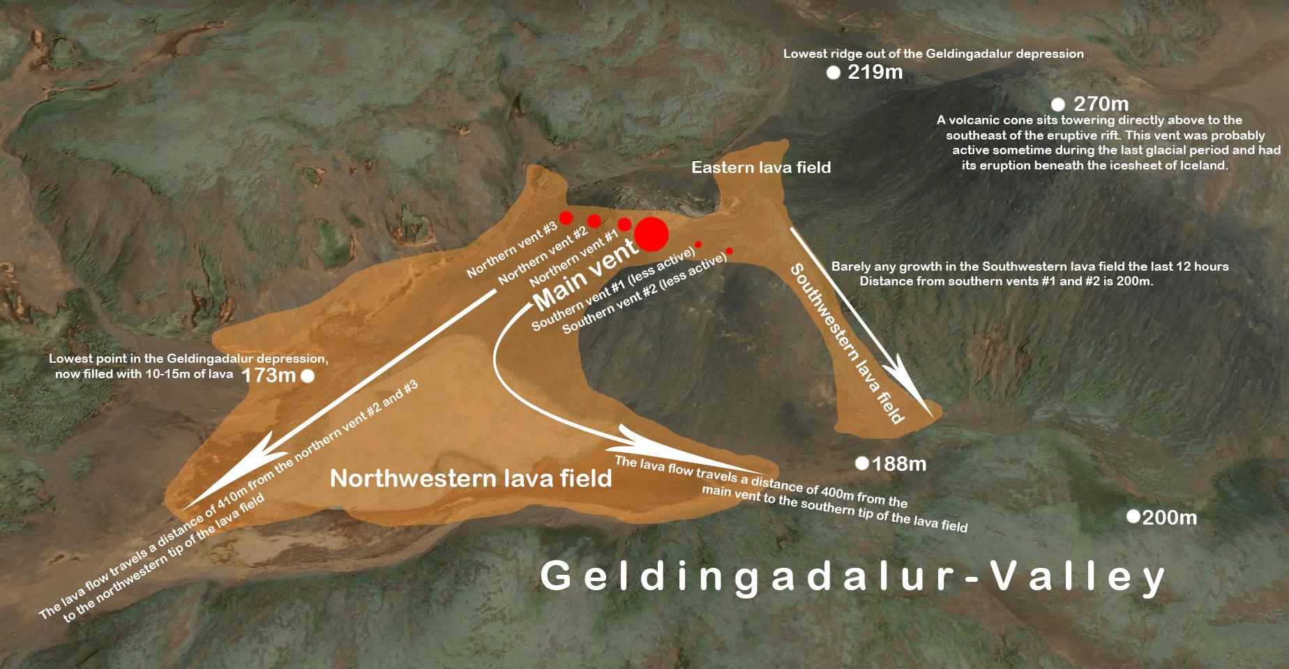
On Friday 19th March 2021, a volcanic eruption began in south-west Iceland, near the capital, Reykjavik. The eruption near Mount Fagradalsfjall, about 20 miles southwest of Reykjavik, took place at 8:45 pm local time. Molten rock breached the surface in a valley near a flat-topped mountain named Fagradalsfjall (beautiful valley mountain), in the region of Geldingadalur (Dale of the Geldings), six miles from the nearest town.
Immediately following the eruption, Iceland’s prime minister Katrín Jakobsdóttir announced on Twitter, “A volcanic eruption has begun in Fagradalsfjall on the Reykjanes peninsula. We are monitoring the situation closely, and as of now, it is not considered a threat to surrounding towns. We ask people to keep away from the immediate area and stay safe”.
In the four weeks leading to the eruption, more than 50,000 earthquakes occurred on the peninsula, a huge jump from the 1,000-3,000 registered each year since 2014. Several of these earthquakes exceeded magnitude 5.
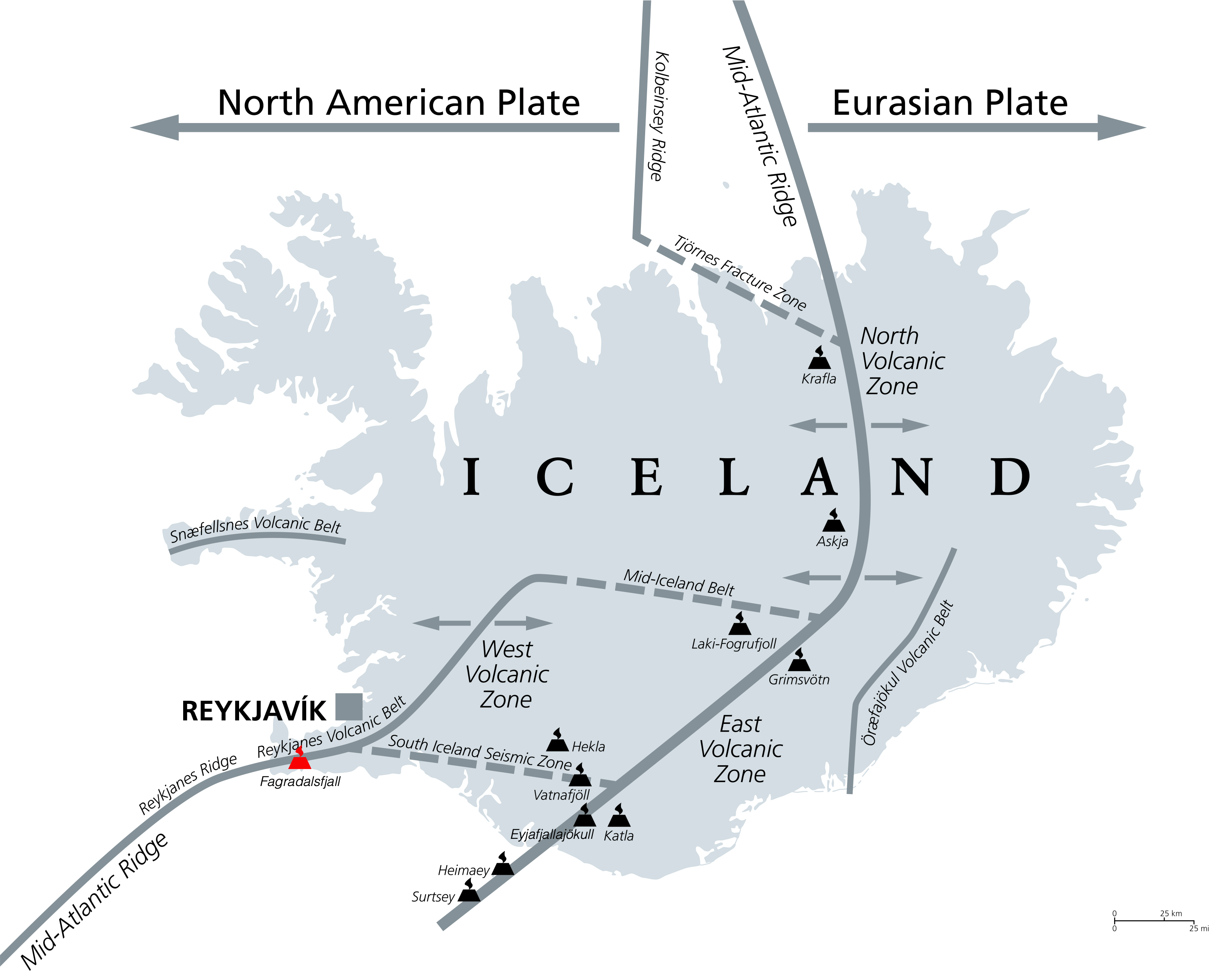
The eruption occurred on the Reykjanes Peninsula in Gledingadalur valley, close to Fagradalsfjall, a mountain 20 miles south-west from the capital, Reykjavik. Sitting on a landward portion of the continuously spreading Mid-Atlantic Ridge is no stranger to earthquakes. But since late 2019, they have become more frequent and more energetic. Icelanders on the peninsula, particularly those in the coastal town of Grindavík, have had trouble sleeping lately due to the constant shaking.
A fissure (crack in the Earth’s surface), approximately 200 m long, opened, releasing lava. Though considered small, the eruption spewed more than 10 million square feet of lava, sometimes in fountains reaching heights of more than 90 m.
Meteorologists said the eruption was small. The area is uninhabited, so the eruption is not expected to present any danger. Lava is trapped within the Geldingadalur valley, which needs to fill with lava at least 25 to 30 metres thick before it pours out of the valley.
The main hazard from the eruption is the potential danger of sulphur dioxide gas.
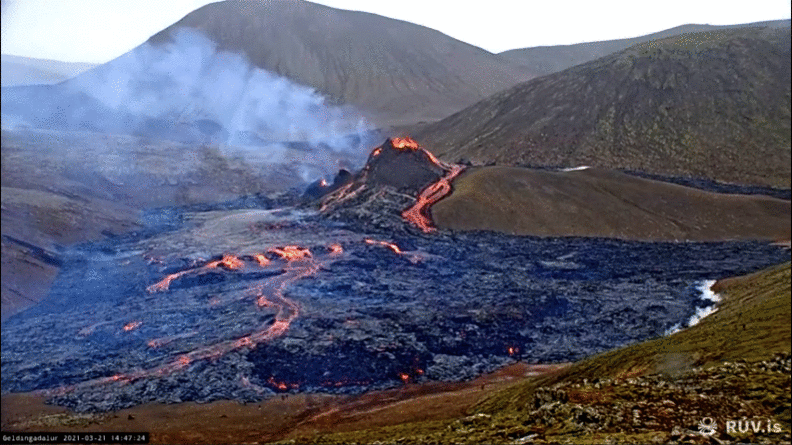
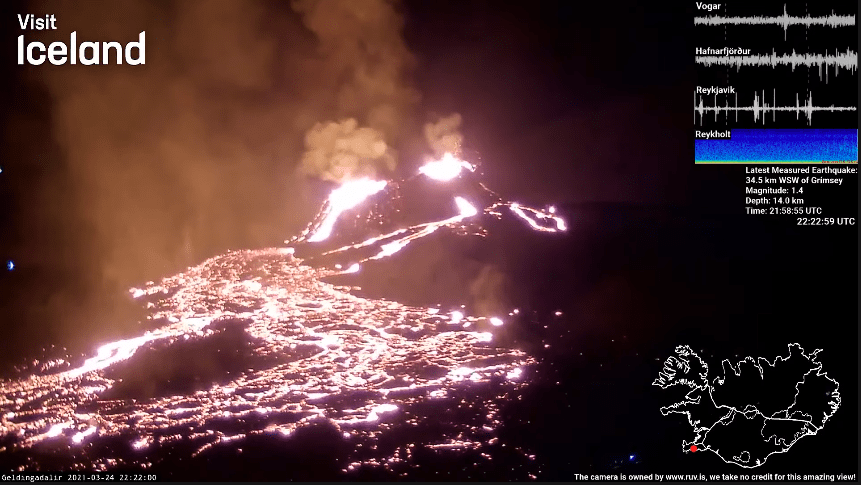
One image was taken every 10 minutes over a 4 hour period on the afternoon of Sunday 21st March 2021. Source images from www.ruv.is
The eruption is the first in this part of Iceland — the Reykjanes Peninsula, home to Reykjavik, where most of the country’s residents live, in 781 years. And it was the first time this particular volcano had erupted in about 6,000 years.
Experts say around 300,000 cubic metres (10.5 million cubic feet) of lava have poured out, but the eruption is deemed to be relatively small and controlled.
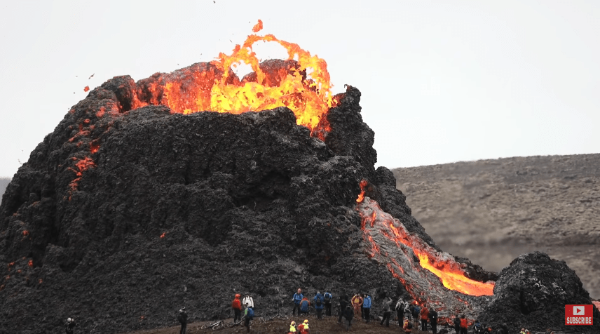
Lava first poured out of a meandering fissure, however over the weekend, the eruption focused its output on a single spot, building a steep, towering cauldron of freshly cooled rock. Smooth rivers of lava crept around blockier, rubble-like lava. Lava flowing at a steady pace caused the cone to suffer a few partial collapses as it flung blobs of lava across the scorched earth.
Ejected molten lava lands on the sides of the vent and solidifies, and over time builds a cone around the vent. This is typical of effusive fissure eruptions of basaltic lava. The spatter cone is relatively weak and is susceptible to collapse. When this occurs, large volumes of lava flow out of the vent rapidly as now unconfined lava. These events are unpredictable and can immediately change the direction and speed of a lava flow, as shown. The video below features the partial collapse of the spatter cone.
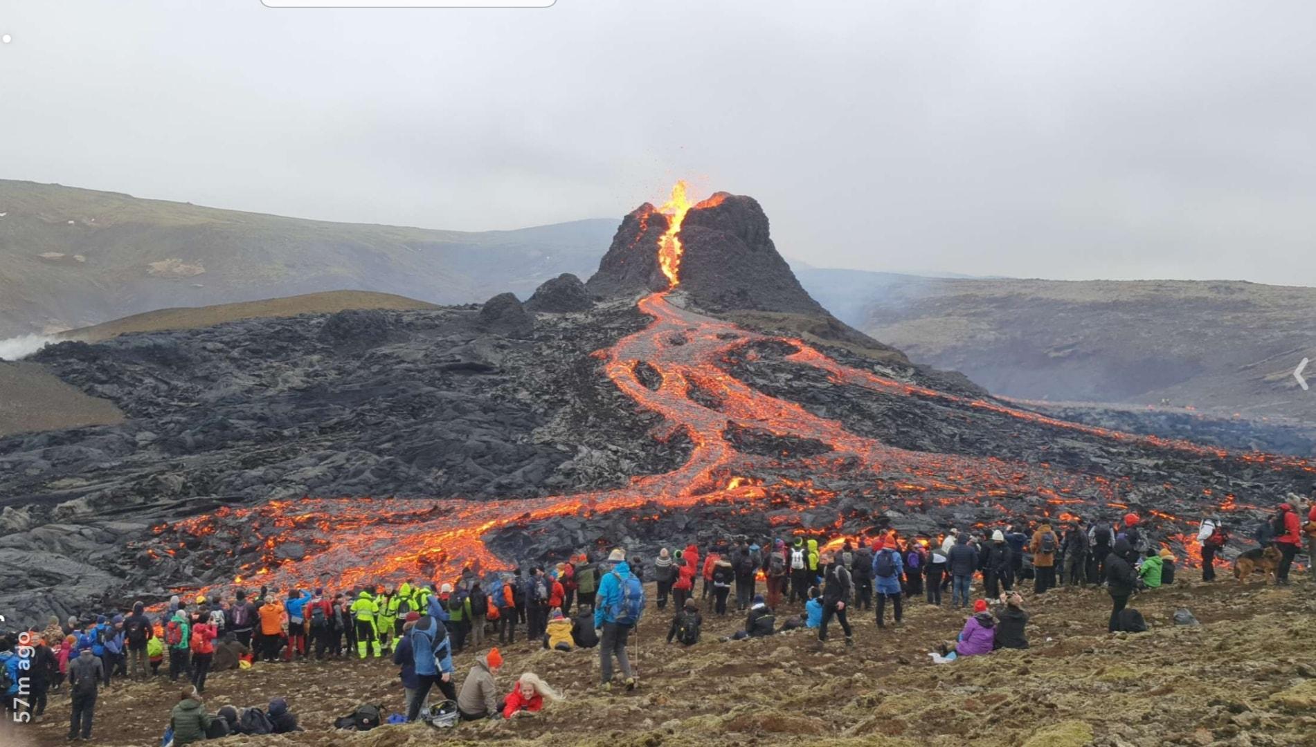
The tourists below put themselves at risk by getting so close to the spatter cone.
Tourists close to the spatter cone.
The site was initially blocked off, but from the afternoon of Saturday 20th, March 2021, people were allowed to make the trek. People hiked to the area over the weekend to witness the eruption up close, and local helicopter companies are offering tours from Reykjavik.
Crowds flock to Fagradalsfjall – image courtesy of Guðni Oddgeirsson
By Monday, the site was blocked again due to high gas pollution levels and poor weather conditions. Emergency services had to rescue several people from the area on Sunday evening.
Now that magma has reached the surface, the earthquakes have mostly subsided.
On Wednesday, 24th April, the main cone was joined by another large cone, formed when two smaller ones merged.
Two large cones on Wednesday 24th March
Iceland frequently experiences earthquakes and volcanic eruptions because it sits between two tectonic plates (the North American and Eurasian plate), moving in opposite directions, forming a constructive plate margin.
Geologists describe the eruption as “effusive”, in which lava flows out of the volcano onto the ground, as opposed to “explosive”, wherein magma is violently fragmented and rapidly expelled from a volcano.
Scientists suggest the heightened volcanic activity represents a transition from a gradual opening of the Mid-Atlantic rift to a considerably more dramatic phase when both sides of the Reykjanes Peninsula are rapidly pulled apart. When a geologic rift quickly pulls the land apart like this, it creates a space, and magma rushes up to fill it in.
Scientists on site made use of nature to cook up a meal!
Unlike the eruption in 2010 of the Eyjafjallajökull volcano, which halted approximately 900,000 flights and forced hundreds of Icelanders from their homes, this eruption is not expected to spew much ash or smoke into the atmosphere.
Below are resources covering the current eruption of Fagradalsfjall, Iceland.
The eruption that started on Friday 19th March 2021 near Iceland’s capital Reykjavik seems to be subsiding, scientists say. – BBC News – update: they clearly got this wrong!
Europe’s most active volcano, Mount Etna, has been hitting the headlines recently after a series of spectacular eruptions. In Etna’s first eruption of 2021, explosive lava fountains reached over 1500 m in one of the most amazing eruptions in decades.
Mount Etna, located on the island of Sicily, has been largely dormant for the past two years. The stratovolcano (composite) dominates the skyline of the Italian island, where it sits on the eastern coast.
Located between the cities of Messina and Catania, it is the highest active volcano in Europe outside the Caucasus – a region between the Black Sea and the Caspian Sea – and the highest peak in Italy south of the Alps.
The recent activity is typical of a strombolian eruption among the normal activities of the more than 3,300-metre-high volcano. The recent eruption is the strongest explosion in the southern crater since it was discovered in 1971.
On Monday 22nd February 2021, at around 11 pm, the lava fountains, surrounded by gigantic clouds of smoke, exceeded 1,500 metres (4,900ft) in height, while thousands of rock fragments, some the size of fridges, were thrown from the crater into the sky for several kilometres.
Etna is a hyperactive volcano with over 3,500 years of historically documented eruptions. The volcano has been erupting on and off since September 2013. Since September 2019, it’s been erupting from its various summit craters virtually continuously. In December 2020, Etna’s explosive activity and lava output began to spike, and in February 2021, it has been launching fluid lava skywards.
Etna is an unusual volcano in that it can produce explosive eruptions of runny lava and release slower flowing, thick lava flows. Scientists are still trying to work out why this is the case.
The magma from the latest eruption appears to be coming up from deep within the mantle. Extremely hot, fluid magma is rapidly rising through the network of conduits within and below the volcano. However, there is another factor that is contributing to the current explosive eruptions.
There are high quantities of water vapour in Etna’s magma, which makes it explosive. The water does not cool the magma. As the molten magma approaches the surface, the pressure drops, and the bubble of water vapour expands violently, leading to lava being ejected out of the volcano.
Following each explosive lava fountain, less gassy magma lingers just below the vent. This is then cleared when a new volley of gassy magma rises from below. These explosive eruptions are known as volcanic paroxysms.
Authorities have reported no danger to the nearby towns, however, local airports have been temporarily closed, as has the airspace around the volcano. Etna’s last major eruption was in 1992. Despite the explosive nature of the recent eruption, there is no risk to the population, other than from the ash that covers buildings and smoke that can, after a few hours, cause breathing problems. In March 2017 vulcanologists, tourists and a BBC film crew were injured during an eruption when a flow of lava ran into snow, producing superheated steam that sent fragments of rock flying in all directions.
Scientists have proposed ten golden rules for tree-planting, which they believe is a top priority for all nations this decade.
Experts from the Royal Botanic Gardens, Kew say that planting trees is a brilliant solution to tackling climate change and protecting biodiversity; however, the wrong tree in the wrong place can cause more harm than good.
Forests are essential to life on Earth. Not only do they provide habitats to three-quarters of the world’s plants and animals, but they also offer food, fuels and medicines as well as soaking up carbon.
However, forests are disappearing at an alarming rate. An area of pristine tropical rainforest the size of Denmark is lost every year.
Reforestation, the restoration of forests that have recently been lost, could protect biodiversity and help fight global climate change by removing huge amounts of carbon dioxide from the atmosphere. There is a range of ambitious tree-planting projects happening around the world to replace lost forests.
The UK Government aims to plant 30,000 hectares (300 sq km) of new forest every year by the end of this parliament.
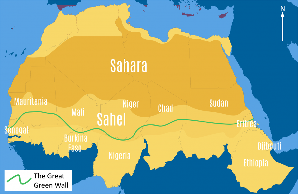
There is an ambitious project in Africa to grow a green wall of trees spanning 5000 miles (8,048km) across the entire continent, from east to west. The project, which will become the largest living structure on Earth, will help fight the climate crisis and combat desertification.
Planting trees is an essential solution to protecting biodiversity and combatting climate change. However, the process is surprisingly complex. The right trees have to be planted in the right place, if not it can cause more damage than food.
Natural forests, containing a wide range of plants, animals, and fungi, are often replaced by commercial plantations where trees are harvested after a few decades. Afforestation is more effective when people try to recreate forests similar to natural forests and provide benefits to people, the environment and nature, and capturing carbon.
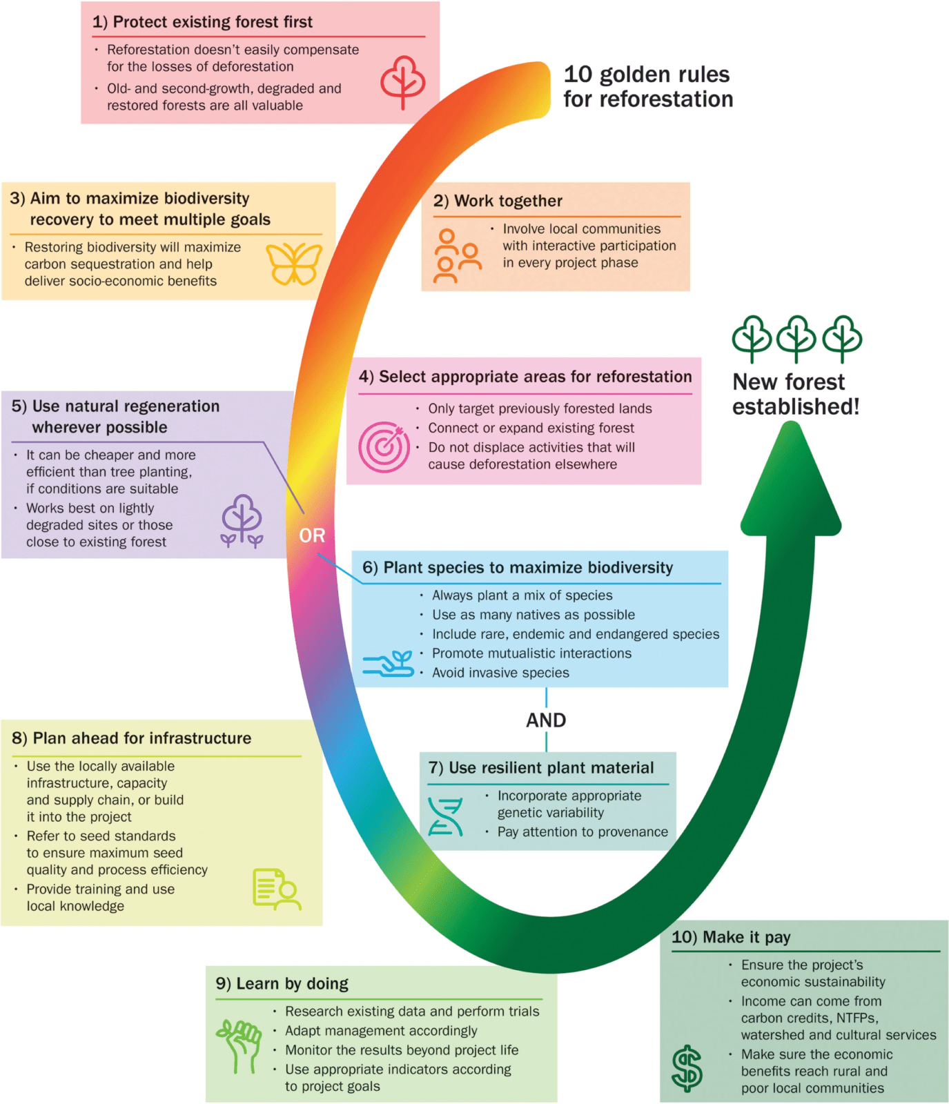
A recent review led by Kew scientists and Botanic Gardens Conservation International (BGCI) proposes ‘ten golden rules for reforestation’ to boost benefits for people and the planet. The rules are:
Protect existing forest first
Work with local people
Maximise biodiversity recovery to meet multiple goals
Select the right area for reforestation
Use natural forest regrowth wherever possible
Select the right tree species that can maximise biodiversity
Make sure the trees are resilient to adapt to a changing climate
Plan ahead
Learn by doing
Make it pay
An overview of each rule is summarised in the diagram below.
Describe the distribution of forest change shown on the choropleth map
This question is asking you to describe the distribution (spread) of forest change shown on the choropleth (shading) map. As this is an interactive choropleth map you can click on the colours in the scale to highlight the patterns. Describing patterns on a choropleth map is easy using the TEA tool as it provides a structure to your answer. TEA stands for trend, examples and anomalies.
Trend
To begin with, it is useful to include an opening statement about the general distribution (pattern/spread) shown on the map. You could do this by asking yourself does the choropleth map show the global annual change in forest area in 2015 even or uneven?
Paragraph starter: The global annual change in forest area in 2015 is even/uneven.
Examples
Next, you need to discuss the patterns on the map giving examples. You could consider:
What continents/countries are experiencing a decline in forest area?
Are the countries mainly HICs, NEEs or LICs?
Are they near the equator or further away?
Are they inland or coastal?
What continents/countries are experiencing an increase in forest area?
Are the countries mainly HICs, NEEs or LICs?
Are they near the equator or further away?
Are they inland or coastal?
Anomalies
Finally, consider any patterns/examples that stand out. In this example, are there any HICs (wealthy countries) that are experiencing high levels of decline in forest cover – top tip – check out North America!)? Are there any LICs/NEEs that are experiencing high levels of forest cover increase (have a look at Asia!)?
https://www.internetgeography.net/wp-content/uploads/2021/01/Tree-Planting-scaled.jpg3561600Anthony Bennetthttps://www.internetgeography.net/wp-content/uploads/2024/01/Internet-Geography-Logo.pngAnthony Bennett2021-01-30 19:25:222021-01-31 14:47:43Ten Golden Rules for Tree-Planting