Acronyms in geography to improve writing
Acronyms are a great way of supporting students when writing like a geographer. They provide a simple framework for students to follow when answering different types of geographical questions. If embedded throughout key stage 3 and 4 they are powerful tools for learners to draw on in the tension-thick exam hall.
Having reached out to Twitter for acronym suggestions, we’ve pulled together a range of strategies that may be useful to you and your students. Many thanks to everyone who contributed!
#geographyteacher What acronyms to you use in geography to encourage students to develop their answers?
— internetgeography.net 🌍 (@InternetGeog) August 16, 2019
We do not recommend teaching students all of the techniques below. It is more useful to cherry-pick a small number to try. Also, while acronyms provide support and structure to students there is a risk that answers can become too formulaic. Students need to be taught how to use these acronyms effectively – knowing when and how to confidently apply or deviate from them.
If we’ve missed out a useful acronym please leave a comment at the bottom of the page. If you have any resources you’re prepared to share based on these strategies please send a copy to [email protected].
Acronyms for thinking synoptically
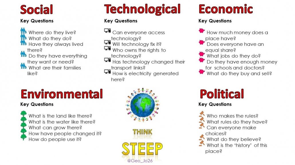
STEEP – Social, Technological, Economic, Environmental & Political (includes Historical)
Why use it?
A useful way of encouraging students to make connections.
The image below, provided by @geojosie, provides a structure for using STEEP.

STEEP – encouraging learners to think synoptically
Acronyms for answering geographical questions
SEE – State, explain, example
Why use it?
Provides a simple structure when answering questions. Students will give an answer (state), explain it and back it up with an example.
PEE – Point, explain, example
Why use it?
Provides a simple structure when answering questions. Students will give a point, explain it and back it up with an example.
The video below, by Kit Rackley of GeogRamblings, explains the technique in a geographical context.
PEEEL – Point, explain example, evaluation and link
Why use it?
Further development on the PEE acronym.
PEDaL – Point, evidence/explain, develop, link
Why use it?
Useful for explaining answers and making links back to the question.
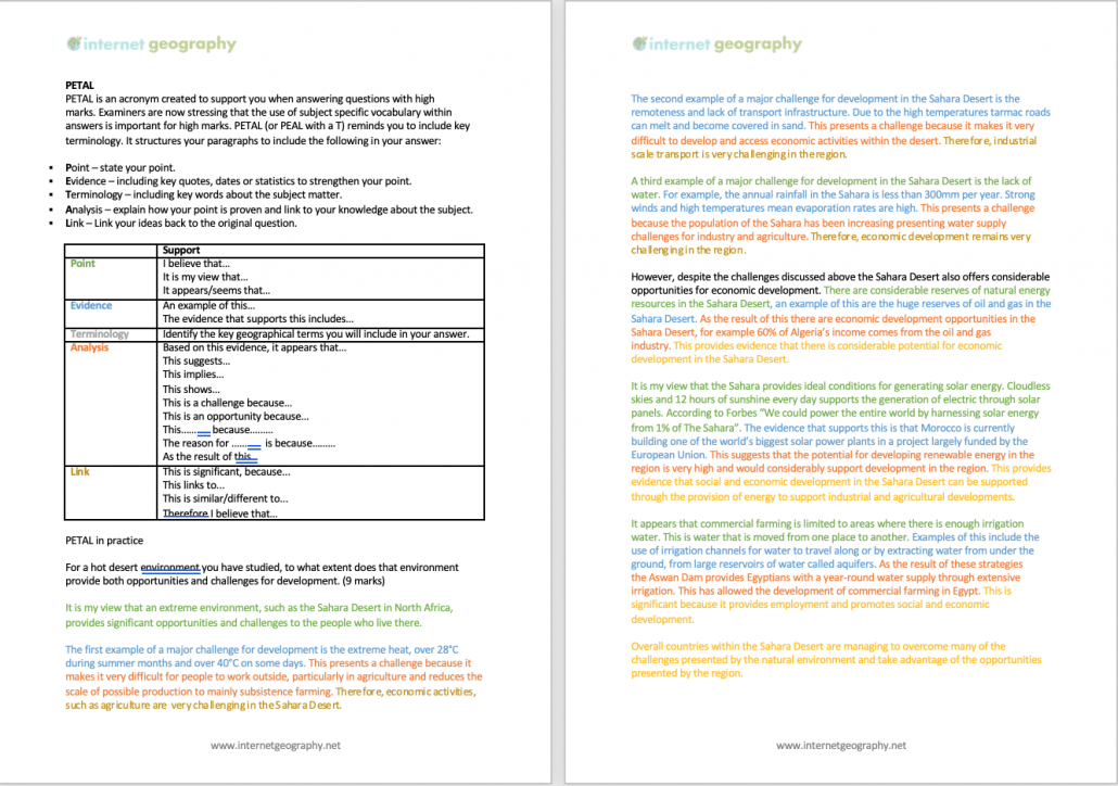
PETAL – Point, evidence, this means that, as a result, link.
Why use it?
A development of PEDaL that provides further structure to explanations and considers impacts.
PELE – Point, explain, link, evidence
Why use it?
Legendary footballer!
SHEEP 🐑 Social, historical, economic, environmental, political
Why use it?
Supports development of answers, particularly for high tariff questions.
Acronyms for geographical distribution/patterns/locations
CLOCCK – Continent, latitude/longitude, ocean/sea, country, compass, kilometre
Why use it?
A technique for describing geographical locations on a map.
GSE Generally, specifically and exception
Why use it?
Useful for distribution/location questions
Acronyms for graphs/data
TEA – Trend, example, anomaly
Why use it?
Useful for analysing graphs.
TREE – Trend, rate of change, examples/evidence, exceptions
Why use it?
Useful for analysing graphs, this structure ensures students cover all possibilities when analysing data.
TEAL – Trend, example, anomaly, links
Why use it?
Useful for analysing graphs.
PALMS – Pattern, anomaly, least, most, stats
Why use it?
Useful for analysing graphs and maps.
PADL – Patterns, anomalies, data, links to topic(s).
Why use it?
Ideal for resource-based questions.
PDA – Patterns, data, anomalies
Why use it?
Ideal for ensuring students include data in descriptions.
FART – Figures, anomalies, rate and trend.
Why use it?
The students will remember it! Useful to remind them of rates and trends in data.
GEE it’s a graph! Generally, examples include, exceptions include…
Why use it?
Particularly useful for sentence starters.
TRASH – Trend, range, anomalies, smallest, highest
Why use it?
A comprehensive range of areas to cover when investigating data.
Acronyms for factors affecting climate
WORLD – Wind direction, ocean currents, relief, latitude, distance from the sea
Why use it?
Simple structure for explaining factors that affect climate.
Acronyms for exam technique – reading the question
GAMES – Geography (what knowledge will I apply?), ask (what is the question asking me to do with that knowledge?), marks (how many is it worth and how will I get top marks?), extra (do I need to use resources, maps, graphs etc.)
Why use it?
A great way to encourage students to consider what the question is asking them to do.
BUG – BOX the command word, UNDERLINE the key term/topic, GLANCE back at the question regularly.
Why use it?
Sometimes students can be guilty of regurgitating their geographical knowledge in an exam without actually answering the question. BUG the question is a great technique for students to deconstruct exam questions and increase their chances of picking up marks by writing an answer appropriate to the question.
Acronyms for decision making
MADASS – My choice, advantages, disadvantages, alternatives (compare to), sustainability, sum up.
Why use it?
A great way to encourage students to consider balance when completing decision-making activities.
If you are an Internet Geography Plus subscriber you have free access to the new resources we’re developing to support students in the use of acronyms to improve their answers to geographical questions. Click the image below to access. Get a low-cost subscription here.
Odd One Out – Coasts
SaveSave


