Strategies for teaching geographical vocabulary
Developing knowledge organisers for AQA GCSE geography units provided a stark reminder of the sheer number of geographical terms students need to understand to be successful in geography. As a result, I have included seventy-four key terms for the documents covering River Landscapes in the UK alone.
AQA has produced a document containing key terms and definitions for each GCSE geography unit. However, it falls short of including all the terms students need to know. When adding vocabulary to the knowledge organisers, it reminded me of the significant number of tier three literacy terms students need to be able to use. It also made me reflect on my time in the classroom and that, in all honesty, I didn’t do enough to teach these critical terms to my students explicitly. I think I probably got in the comfort zone where I assumed students would know and be able to use these terms.
The Geographical Association provide a reminder of the importance of literacy in geography.
“The use of language is an integral part of learning geography, and literacy skills are essential for geographical understanding. It is through language that students develop their ideas about geography and communicate them. “
Rather than consider literacy as a discrete element, literacy should be a foundation of geographical education, including the explicit instruction of tier three vocabulary.
“Literacy in secondary school must not simply be seen as a basket of general skills. Instead, it must be grounded in the specifics of each subject. Crucially, by attending to the literacy demands of their subjects, teachers increase their students’ chance of success in their subjects. Secondary school teachers should ask not what they can do for literacy, but what literacy can do for them.”
Education Endowment Foundation – Improving literacy in secondary schools
Many learners may struggle with tier 3 (subject-specific) vocabulary as it is often unfamiliar. A Year 8 student, for example, will rarely see ‘gross national product’ or ‘tributary’ in their wider reading.
Learners who can’t understand subject-specific terminology can’t access the taught content. Fortunately, content and vocabulary don’t have to be separate entities.
Approaches to the development of subject-specific language
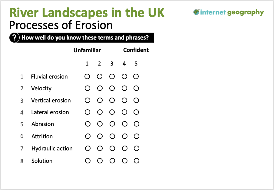
- Identify key terms – Before teaching a lesson or sequence of lessons, identify the geographical terms students need to be able to use fluently. Find out the words students already know and which you will focus on. To do this, you could provide them with a continuum, as shown below.

Identify key terms – Available in PPT format to Internet Geography Plus subscribers.
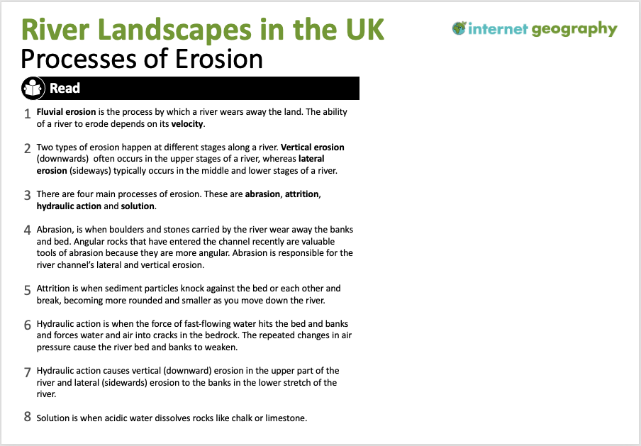
- Present the terms in context – Give the class a passage of text containing the keywords used in context. Once they see the big picture, you can start exploring their meanings.

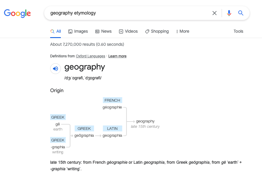
- Word morphology – Breaking words into prefixes, suffixes, and roots is an effective way to help students link with familiar language. So many terms that seem intimidating initially contain parts that students already know. For example, a biome is a large-scale ecosystem. Breaking this down and looking at the prefix ‘bio’ – life – will help them define the new word ‘biome’. Online tools such as Etymonline Online are useful for investigating etymology. Additionally, a Google search of a keyword followed by etymology provides a very useful overview through a branch diagram, as shown below.

Geography etymology branch diagram
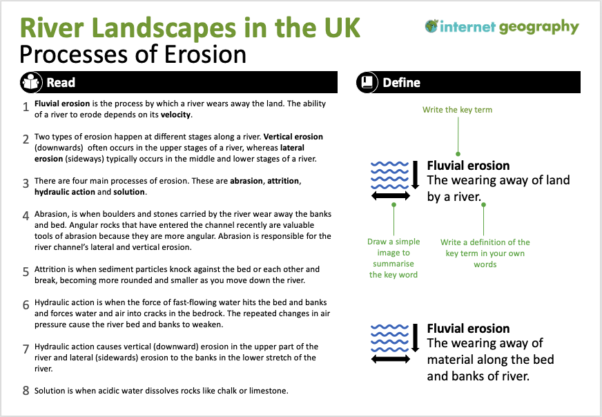
- Images and definitions – Ask the students to draw a simple image to summarise the word. They should then write a definition for each word. As they do this, check for understanding as you circulate. Address misconceptions with individuals and provide whole class feedback.

Images and definitions – A downloadable PPT of this is available to Internet Geography Plus subscribers.
- Video – Videos are often shown in geography lessons to introduce new information. A problem with this is that students may be unfamiliar with the technical terms used in the video. Perhaps we should rethink how we use videos in the classroom by showing them after students have engaged with geographical terms (through the exercises above) so that they can process the information more effectively.
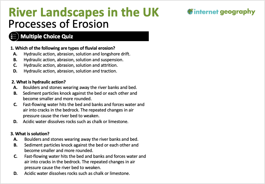
- Low-stakes quiz – Regular quizzes are a great way to revisit the course content and beat the forgetting curve. Multiple-choice and short-answer questions are ideal for this.

Low-stakes quizzes – Internet Geography subscribers can access this slide in PPT format.
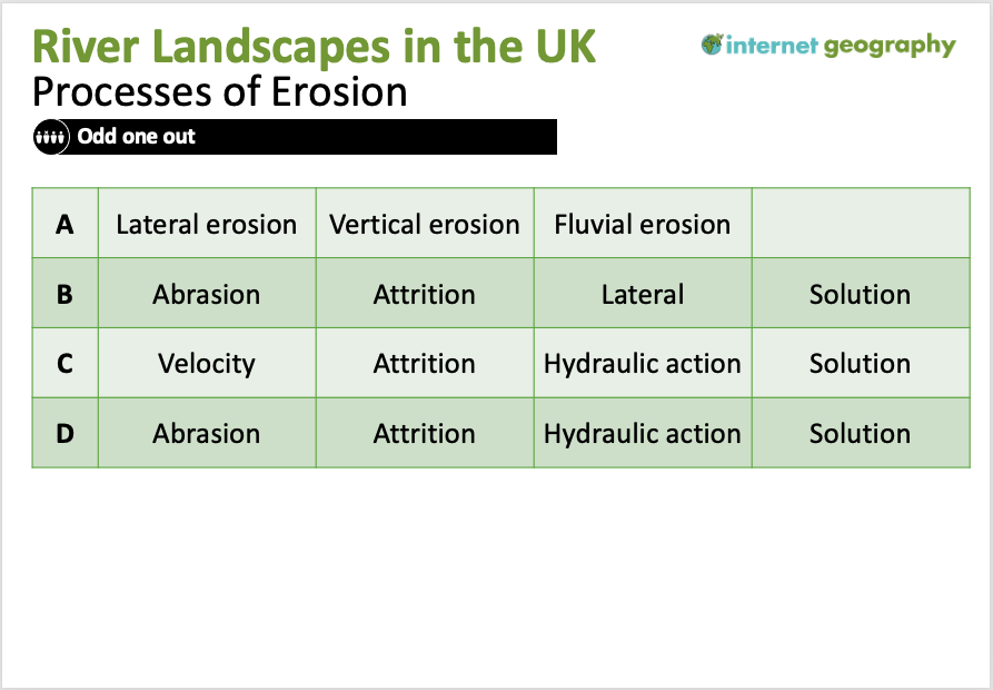
Internet Geography Plus subscribers can access a significant bank of multiple-choice booklets, and Google/Microsoft forms multiple-choice quizzes. - Odd-one-out – Odd one out activities encourage the retrieval of prior knowledge, promote critical thinking and provide opportunities to practice geographical vocabulary. Provide students with a collection of words (3-4) where the majority are connected. Students then identify the word that is the odd one and explain the reason. Odd one-out activities encourage students to think about characteristics and processes. To complete the task successfully, students must know the vocabulary’s meaning, enabling them to identify similarities and differences. These skills have a positive impact on the geographical communication not only of individual students but of the class as a whole.

Odd one out
Internet Geography Plus subscribers have access to a collection of odd one-out activities.
- Keyword dominoes – There are various ways students can use dominoes to build an understanding of key terms. The keywords could be added to dominoes that students match up at the most basic level. The next level would be to add a definition to one side of the domino with a key term on the other. Finally, students could match key terms that link, so long as they can explain the connection, e.g. vertical erosion will match abrasion as abrasion leads to vertical erosion in the upper stages of a river.
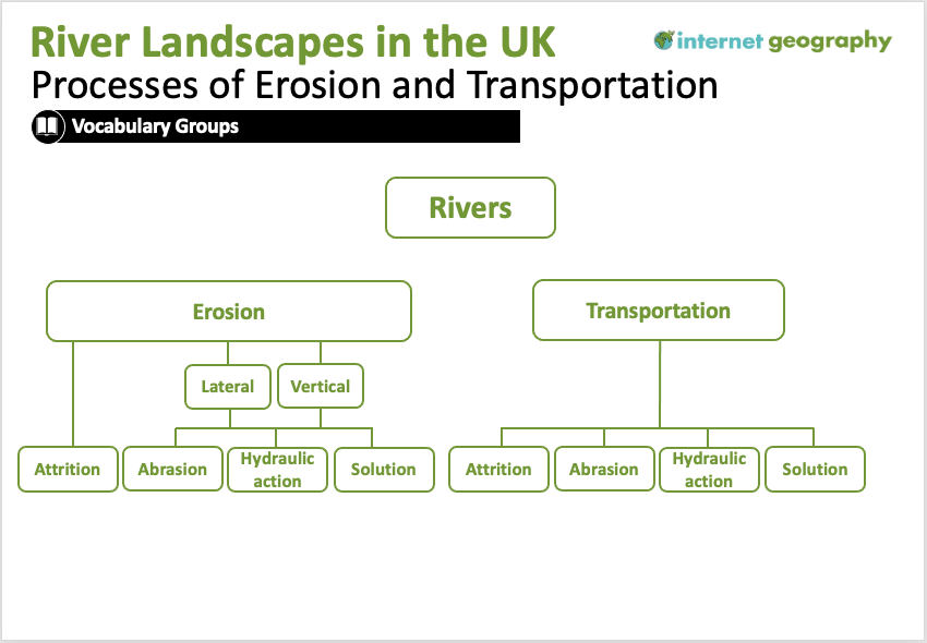
- Vocabulary groups – Grouping geographical terms can help students build reference points in their new vocabulary. In the case below, three processes of erosion that lead to lateral and vertical erosion are grouped together. A blank version of the diagram below could be given to students to populate with key terms until they become confident in using vocabulary groups. Students could develop their own vocabulary groups when they become more familiar with the studied terms.

Vocabulary groups
- Flashcards – Flashcards are a common revision tool used by students and are one of the most effective ways for motivated learners to study and retain information. Students should be encouraged to create keyword flashcards throughout the course. Why not share our guide to creating flashcards? Alternatively, we’re building a bank of revision flashcards that can be accessed in our interactive revision area.
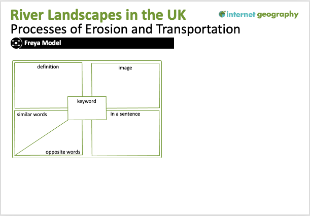
- Fraya Model – The Freya model is a graphic organiser that provides a simple but effective framework to help students to organise their understanding of a new geographical term.

The Freya Model in geography.
A template for the Freya Model is available in an editable PPT format to Internet Geography Plus subscribers.You can learn more about the Freya model on Alex Quigley’s blog.
Students must regularly revisit these key terms to be committed to their long-term memory. Therefore retrieval practice activities will be essential over the long term.
If you’ve successfully used a strategy to support teaching geographical vocabulary, please join the discussion and let us know below!