Characteristics, distribution and measurement of natural hazards
A natural hazard is a natural event, such as a volcanic eruption, earthquake, or tropical storm, that has the potential to cause significant harm to people, their belongings, or their way of living, and/or environmental degradation. A disaster occurs when a natural hazard results in loss of life, injury, damage to property, disruption to society and the economy, or harm to the environment. Risk is the likelihood that a hazardous event will lead to these negative outcomes. Vulnerability describes the geographical and social conditions that make a community more prone to experiencing harm from a hazard or its effects.
Natural hazards can be characterised in several ways, including:
- Magnitude: Refers to the size of the event, such as the measurement of an earthquake using the Moment Magnitude Scale.
- Frequency: Reflects how regularly an event of a particular size takes place. Sometimes referred to as the recurrence interval, larger events happen less often, but they can be the most destructive to the environment, people, property, and livelihoods.
- Regularity: Some natural hazards, like tropical cyclones, follow a more regular pattern, while others, like earthquakes and volcanoes, are more unpredictable.
- Areal Extent: Describes the geographical space affected by the hazard.
- Spatial Concentration/Dispersion: This deals with how hazards are spread across locations, whether they are focused in specific areas like plate boundaries, coastal zones, valleys, etc.
- Speed of Onset: This varies from quickly occurring events, such as earthquakes, to more gradual occurrences, like tropical cyclones, which might develop over several days.
- Duration: Refers to the length of time the natural hazard persists.
In the first two decades of the 21st century, over 7,300 disaster events were recorded, resulting in more than 1.2 million deaths—an average of 60,000 deaths per year. The total economic loss from these disasters was nearly US $3 trillion. Mega-disasters during this period included the 2004 Boxing Day tsunami, Cyclone Nargis in 2008, and the Haiti earthquake in 2010, which significantly increased the annual average death toll. Storms alone caused approximately 200,000 deaths, with Cyclone Nargis being the deadliest, claiming around 138,000 lives in southern Myanmar and incurring an economic cost of US $4 billion. Storms also caused the greatest financial losses in the Americas, accounting for over 70% of the global economic impact during this time.
Earthquakes and tsunamis were responsible for nearly 60% of disaster-related deaths, while volcanic eruptions, though less frequent (only 1% of hazard events), also caused significant impacts. In 2018, eruptions in Guatemala killed 425 people and affected 1.7 million, while an eruption in Indonesia triggered a tsunami that claimed over 450 lives in coastal communities. Flooding also caused notable devastation, such as the 2021 floods in Europe that killed nearly 250 people, mainly in Germany.
Advancements in forecasting and early warning systems, along with increased access to mobile technology, have improved disaster preparedness and response, reducing fatalities from some hazards like hurricanes and volcanic eruptions. However, factors such as population growth, poverty, urbanisation, climate change, land degradation, and the COVID-19 pandemic have heightened vulnerability in certain regions.
The impact of natural hazards varies significantly across income groups. Although disasters occur relatively evenly across income levels, the number of deaths, people affected, and the scale of economic loss are much higher in lower-income countries. Furthermore, the magnitude of hazards and exposure to them differ between nations, resulting in disparities in human and economic consequences.
Tropical Cyclones (Hurricanes)
Tropical cyclones, also known as hurricanes, are potent low-pressure systems that result in heavy rain, forceful winds, and towering waves and can also lead to other hazards such as flooding and mudslides. Typically covering up to 800 km in diameter, with a calm centre known as the eye, tropical cyclones primarily form in tropical and subtropical areas.
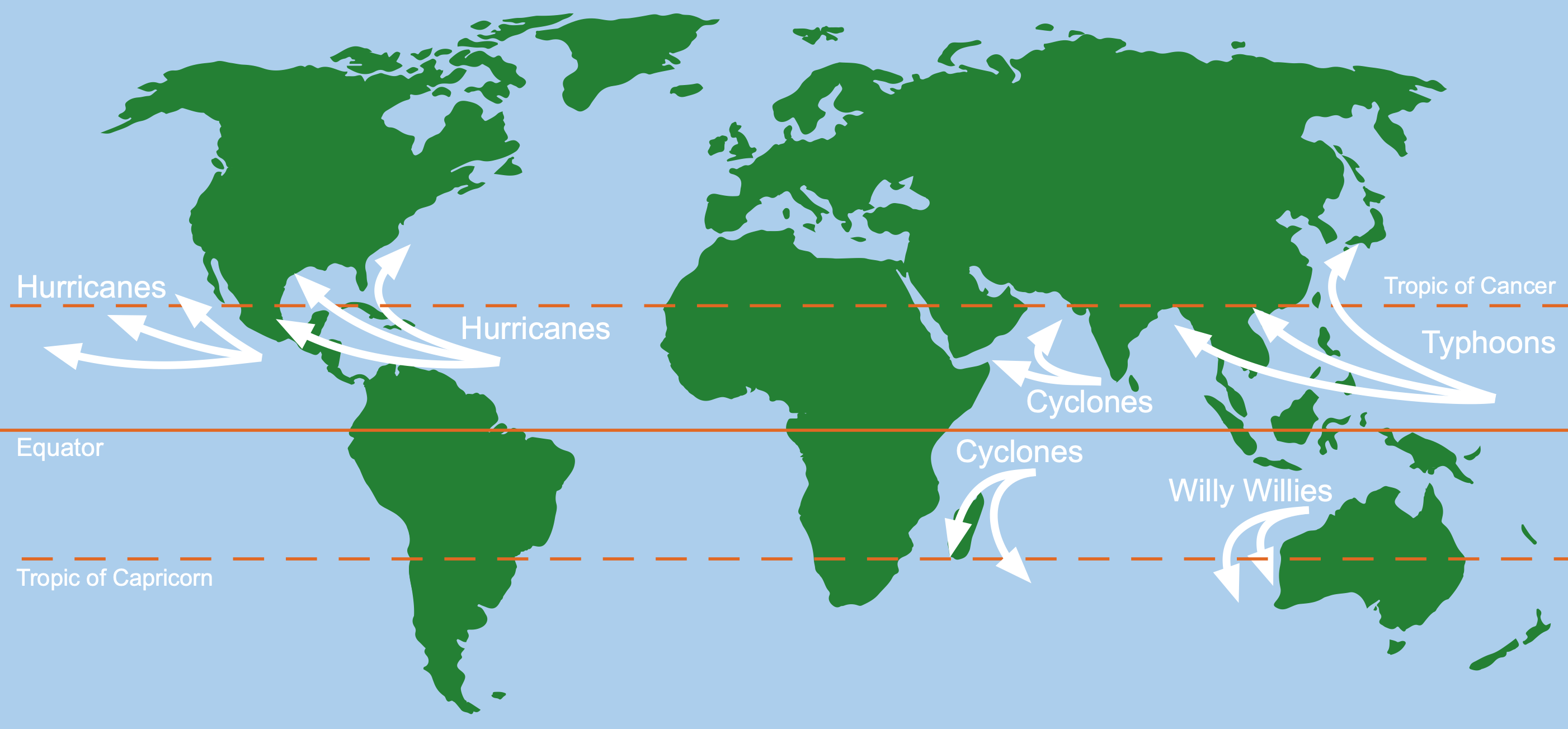
The distribution of tropical storms
Earthquakes
Earthquakes are characterised by sudden and intense shaking of the Earth’s surface. This phenomenon occurs when accumulated pressure forces rock and other materials to break, primarily at plate boundaries where two plates interact. Earthquakes are associated with different types of plate boundaries and can vary in their spatial occurrence:
- Subduction Zones: Linked to broad belts of earthquakes.
- Constructive Plate Margins: Related to narrower belts of earthquakes.
- Collision Boundaries: Correlated with extensive belts of earthquakes.
- Conservative Plate Boundaries: Tend to have a relatively narrow belt of earthquakes.
Focus and Epicentre:
- Focus: The underground point where the earthquake originates. Deep-focus earthquakes typically occur in subduction zones, while shallow-focus earthquakes are common along constructive and conservative boundaries.
- Epicentre: The point on the Earth’s surface directly above the focus.
Measurement of Earthquakes
To quantify the magnitude of earthquakes, scientists have developed various scales:
- Richter Scale: Introduced in 1935, the Richter scale measures the magnitude logarithmically. An earthquake registering 5.0 is ten times more powerful than a 4.0 and a hundred times more powerful than a 3.0.
- Moment Magnitude Scale (M): A newer method measuring the energy released. The figures are often comparable to the Richter scale. An increase of 1.0 on the M scale results in over 30 times the energy release and ten times the amplitude recorded on a seismograph.
Volcanoes
A volcano represents a rupture in the Earth’s crust that allows the escape of hot, molten magma, ash, and cinders, which can form into lava upon reaching the surface. Volcanic activity is primarily concentrated at plate boundaries, both constructive and destructive (subduction zones), and sometimes over areas known as hotspots.
Approximately three-quarters of the Earth’s 550 historically active volcanoes are part of the Pacific Ring of Fire, a well-known zone for volcanic and seismic activity.
Hotspots
An example of hotspot volcanism can be observed in the Hawaii volcanoes in the middle of the Pacific Ocean. A hotspot is a plume of heated material that rises from deep within the mantle, leading to volcanic activity. The Hawaiian Islands are a classic example of hotspot-induced volcanic formations.
Measuring Volcanic Strength: Volcanic Explosive Index (VEI)
Volcanic eruptions are quantified using the Volcanic Explosive Index (VEI). The VEI measures:
- The volume of material erupted.
- The height of the ash cloud produced.
- The extent of damage caused.
The scale ranges from 0 to 8, with eruptions rated above level 5 considered very large and violent. A VEI 8 eruption is classified as a supervolcano, an immense magnitude event with far-reaching impacts.