Several methods exist to prepare for an earthquake, such as issuing warnings and evacuations, designing buildings to withstand tremors, and utilising remote sensing and Geographic Information Systems (GIS).
The primary strategies to address earthquakes include:
- Enhanced forecasting and warning systems
- Remote sensing and GIS
- Effective emergency procedures
- Earthquake-resistant building designs
- Strategic building locations
Enhanced forecasting, warning and evacuation
To predict and monitor earthquakes, various techniques are used, including:
- Measuring small-scale changes in the ground surface
- Detecting ground tilting
- Assessing changes in rock stress
- Monitoring clusters of minor earthquakes
- Tracking changes in radon gas levels
- Observing unusual animal behaviour, particularly in toads
Remote sensing and GIS
Remote sensing and GIS play a crucial role in earthquake preparation by monitoring changes in ground movement and identifying areas at risk. Advanced satellite technologies, such as RapidEye and GeoEye, provide high-resolution imagery that can detect subtle shifts in the Earth’s surface, which may indicate tectonic activity. These tools allow scientists to map fault lines, measure ground deformation, and track seismic activity over time, helping to predict potential earthquake hotspots. By integrating remote sensing data into GIS platforms, researchers can create detailed hazard maps that guide urban planning and infrastructure development to minimise earthquake risks.
GIS is an invaluable tool for managing the impacts of earthquakes, offering real-time and post-event analysis to support decision-making. By overlaying hazard data with information on population density, buildings, and critical resources, GIS helps assess risk and prioritise areas needing immediate intervention. GIS can optimise search and rescue efforts during a hazard event by identifying the most affected zones and the fastest routes for emergency response teams. Additionally, GIS supports litigation solutions by evaluating damaged infrastructure and guiding reconstruction efforts. Long-term recovery strategies also benefit from GIS, as it helps allocate resources efficiently, monitor rebuilding progress, and analyse the effectiveness of mitigation measures to reduce future vulnerabilities.
Effective emergency procedures
Effective emergency procedures are essential for minimising the loss of life and reducing damage during an earthquake. Public education campaigns, regular drills, and robust evacuation plans are key components of these efforts. For instance, Japan observes an annual “Disaster Prevention Day” on September 1st, where schools, businesses, and communities practise earthquake drills to prepare for seismic events. Participants rehearse actions like taking cover under sturdy furniture and evacuating to designated safe zones once the shaking stops.
Emergency plans should also include clear guidance on what to do during an earthquake, such as the widely recognised “drop, cover, and hold on” method, which involves finding immediate shelter under a sturdy object and holding on until the shaking ceases. Comprehensive procedures ensure that residents know evacuation routes, assembly points, and how to access emergency supplies.
In addition to education, authorities must establish early warning systems to provide alerts when seismic activity is detected, giving people crucial seconds to take action. Coordinating with local organisations and conducting routine drills builds community resilience and ensures that procedures are well-practised, enabling a faster and more organised response during an actual event. By incorporating these strategies, the devastating impacts of earthquakes can be significantly reduced.
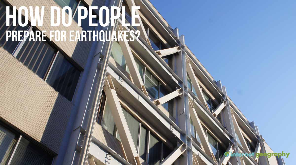
Building design and locations
Buildings can be engineered to endure earthquake shockwaves. Single-story buildings are generally more stable than multi-story ones due to reduced swaying of their potential. Some tall buildings incorporate a “soft storey” at the base, like a parking area on raised pillars, which may collapse during an earthquake, allowing the upper floors to settle onto it and absorb the impact. Reinforcement techniques include constructing foundations deep into bedrock and using steel frames that resist shaking.
Land-use planning is crucial in mitigating earthquake risks. High-density areas and essential services like hospitals and fire stations should not be located near known fault lines. Remote sensing tools like RapidEye and GeoEye satellite data can monitor ground movement changes. GIS can provide valuable land use and infrastructure data, identifying vulnerable areas.