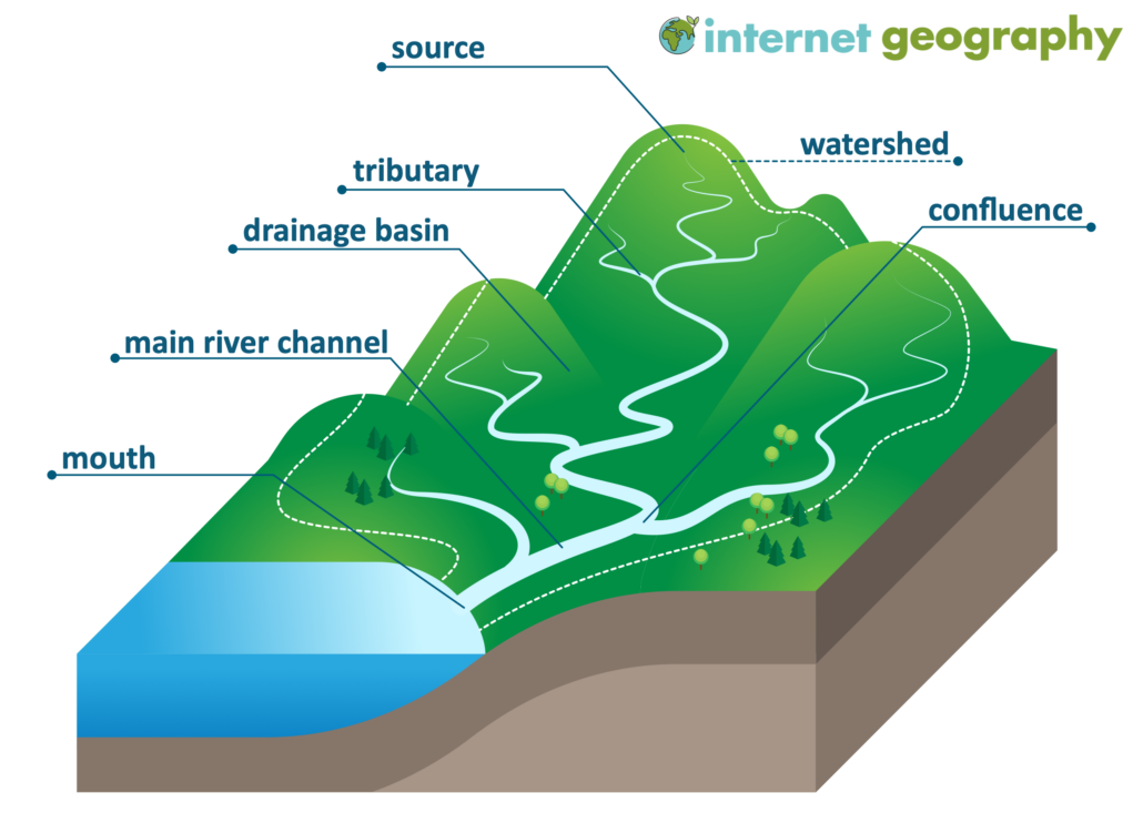
What is a drainage basin?
A drainage basin is an area of land drained by a river and its tributaries.
The water cycle operates as a closed system on a global scale, meaning it doesn’t gain or lose water. However, for a specific drainage basin, it’s an open system – it receives water and other external influences and discharges water and material out of the system. The unique characteristics of a drainage basin include:
- The ‘watershed’ defines the edge of a drainage basin. It’s a raised piece of land that separates one drainage basin from another.
- The ‘source’ is the origin or starting point of a river.
- The ‘mouth’ is the point at which a river ends, typically where it empties into a sea or ocean.
- A ‘confluence’ is where a smaller river (tributary) flows into and joins the main river.
- A ‘river system’ or ‘channel network’ comprises a main river and all its contributing tributaries.
What is the source of a river?
The source of a river is the origin or the initial point from where a river flows. It could be:
- An upland lake or a thawing glacier
- A spring situated in a marshy upland region or a spring at the base of a cliff
From their source, tiny streams are guided by gravity, following the quickest path downhill. They gain water volume from tributaries, the underground water flow, lateral underground flow, and surface runoff.
River System
A primary river might be fed by a large network of tributaries, resulting in no point in the drainage basin being far from a river. This scenario indicates a high drainage density. Conversely, if a main river has few tributaries, it suggests a low drainage density.
What is a river mouth?
Typically, rivers empty into a sea or an ocean, but in some cases, they can flow into lakes which may be situated far from any coast. For instance, the River Volga, Europe’s longest river, drains into the Caspian Sea.

