Distribution of earthquakes and volcanoes
To understand the global patterns of tectonic plates and their movement, you must have an appreciation of the structure of the Earth.
The structure of the Earth
The Earth has four main layers, the inner core, outer core, mantle and crust.
The inner core forms the centre of the Earth and is 1400 km across. The inner core is solid and dense; in fact, it is over five times denser than rocks on the surface. The inner core is made up of iron (80%) and nickel and has a temperature of around 5500°C.
Surrounding the inner core is the outer core. The outer core consists of dense, semi-molten metal and is around 2100 km thick. The temperature of the outer core is between 5000 and 5500°C.
Outside the core is the mantle. The mantle is a semi-molten layer around 2900 km thick. It is less dense than the outer core.
The crust forms the surface of the Earth. The crust is divided into large sections called tectonic plates. Tectonic plates can be either oceanic, continental or a combination of both.
| Oceanic Crust | Continental Crust |
|---|---|
| Thin – 5 to 10 km thick | Thick – 25 to 90 km thick |
| Younger | Older |
| Heavy and dense | Light and less dense |
| The crust is continually being destroyed and formed | Cannot be destroyed |
Check your understanding
Structure of the Earth
Why do tectonic plates move?
The Earth’s crust is divided into large sections called tectonic plates. Tectonic plates lie on top of the semi-molten mantle. Tectonic plates are not static; they move between 10 mm to 180 mm per year, an average of 40 mm. While this does not sound much over a period of millions of years, they move a considerable distance.
There are several theories for the movement of the Earth’s tectonic plates, including convection currents, ridge push and slab pull.
Convection currents occur in the mantle. These convection currents move heat from the interior of the Earth towards the surface.
As the semi-molten rock in the mantle is heated, it becomes less dense than its surroundings and rises. As it reaches the crust above, it spreads out carrying the plates above with it. As the semi-molten rock then cools, it gradually sinks back down to be re-heated.
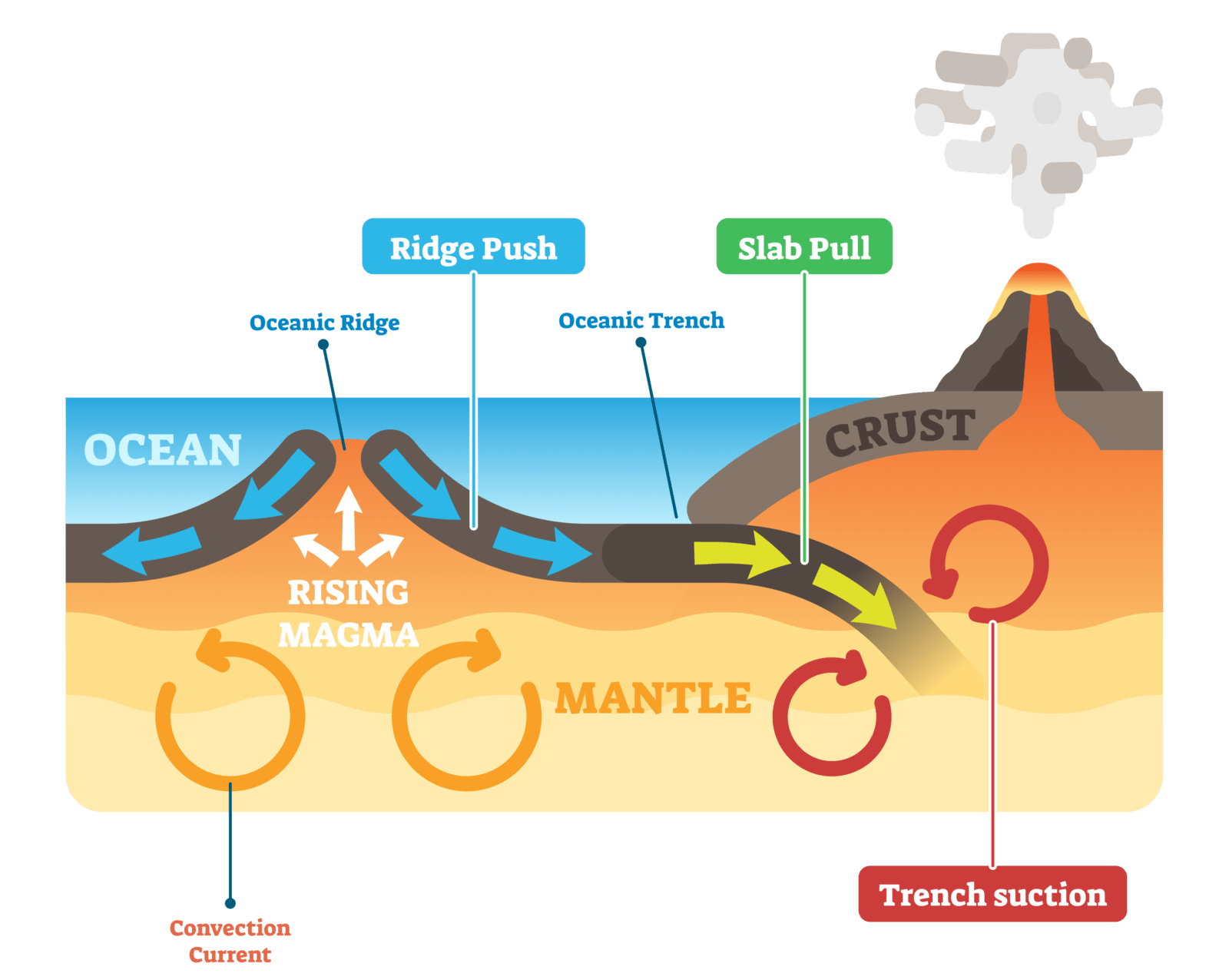
Convection currents, slab push and slab pull are believed to be responsible for tectonic plate movement.
Another explanation for plate movement is ridge push. Newly-formed plates at oceanic ridges (constructive plate margins) are warm, and so have a higher elevation at the oceanic ridge than the colder, more dense plate material further away; gravity causes the higher plate at the ridge to push away causing the plates to move away from each other.
Additionally, at destructive plate margins the denser, oceanic plate sinks into the mantle under the influence of gravity, which pulls the rest of the plate along with it. This is known as slab pull.
Recent research has shown that the major driving force for most plate movement is slab pull because the plates with more of their edges being subducted are the faster-moving ones. However, ridge push has also been presented in recent research to be a force that drives the movement of plates.
Check your understanding
Tectonic Movement
What happens at plate boundaries?
As you can see from the diagram below, tectonic plates move in different directions.
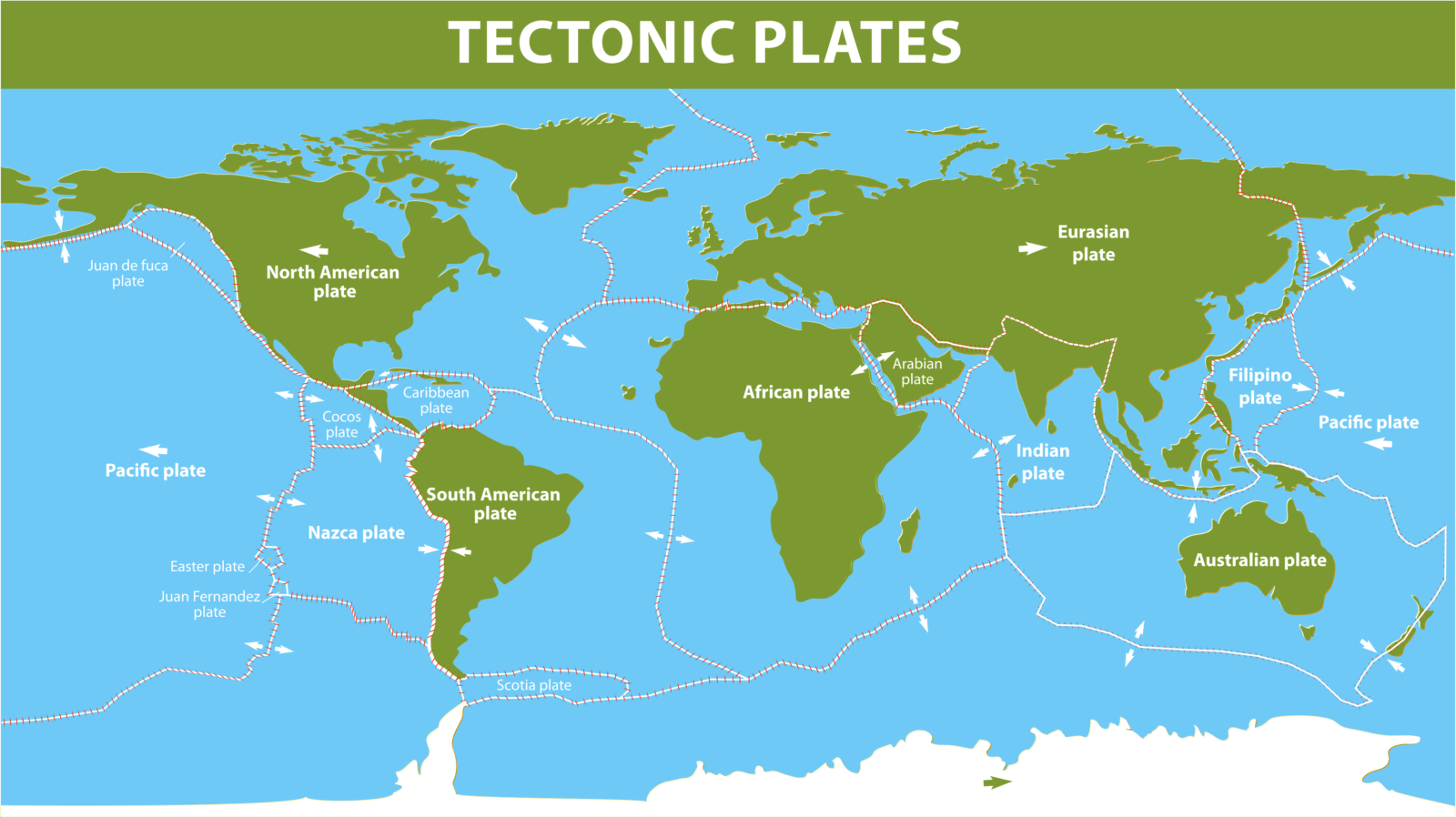
Earth’s major tectonic plates
The point where plates meet is known as a plate boundary or margin. When an oceanic and continental crust move towards each other, a destructive plate boundary is formed. A collision plate margin is formed where two continental plates move together. Where two plates move away from each other, a constructive plate boundary is formed. Conservative boundaries form where two plates slide past each other.
Volcanoes and earthquakes do not occur just anywhere. The map below shows the distribution of recent earthquakes and volcanic eruptions. From the map, you will notice volcanoes and earthquakes mainly occur in narrow bands. When compared to the map above it is clear that the majority of the world’s earthquakes and volcanic eruptions occur along plate boundaries.
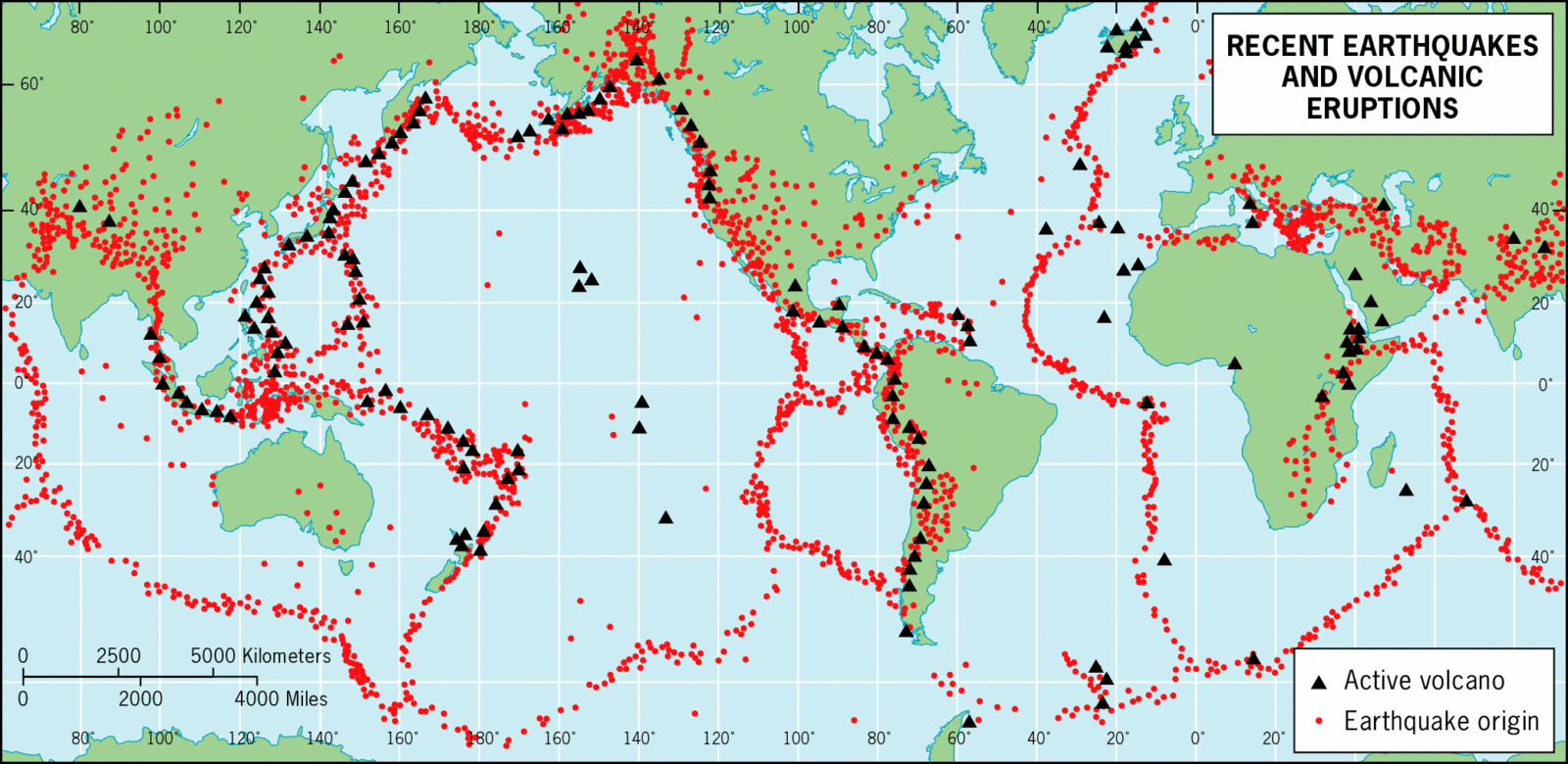
A map to show recent major earthquakes and volcanic eruptions
The table below provides an overview of the characteristics of each plate boundary.
| Type of boundary | Destructive | Collision | Conservative | Constructive |
|---|---|---|---|---|
| Types of plate | Oceanic and continental | Continental and continental | Any | Any |
| Movement | Plates move towards each other. | Plates move towards each other. | Plates move past each other, either in opposite directions or in the same direction with one plate moving faster. | Plates move away from each other. |
| Effect | Oceanic plate subducts (sinks underneath) the continental plate. Old crust is destroyed, also known as a crust bin. | Continental crust folds. | Crust is not created or destroyed. | New tectonic crust is formed. Sometimes referred to as a crust bin. |
| Relief | Fold mountains, volcanoes and oceanic trenches | Fold mountains | Limited effect | The formation of a ridge. |
| Activity | Volcanoes and earthquakes | Earthquakes | Earthquakes | Volcanoes and earthquakes |
Constructive (divergent) plate boundaries
Where two tectonic plates move apart below an ocean, the gap between them fills with molten magma, and the lava that is released constructs new crust. The Mid-Atlantic Ridge is the longest conservative plate margin in the world. It extends the length of the North and South Atlantic oceans where the North and South American plates are moving away from the African and Eurasian plates. The ridge contains many undersea volcanoes and experiences minor earthquake activity. Volcanic activity and earthquakes are relatively gentle compared to other plate margins. Iceland was formed due to the separation of the North American and Eurasian plate.
Where two plates containing continental landmass move apart a rift valley is formed. A rift valley is a lowland region that forms where Earth’s tectonic plates move apart or rift. The most well-known example of this is the Rift Valley in south-east Africa.
Destructive (convergent) plate boundaries
Destructive plate boundaries occur where dense, oceanic crust subduct lighter, continental crust forming a subduction zone. As the oceanic crust sinks below the continental crust, it melts, forming magma. Where magma rises to the surface, it forms explosive composite volcanoes. The Andes mountain range that runs the length of the west coast of South America was formed due to the subduction of the oceanic Nazca Plate below the continental South American Plate.
Volcanoes may form a line of volcanic islands called island arcs where this process occurs within oceans. The islands of the West Indies in the Caribbean were formed in this way.
Mighty earthquakes often occur along destructive plate margins. The fifth-largest recorded earthquake that affected Japan in 2011 occurred along the destructive plate boundary where the Pacific Plate subducts the Eurasian Plate.
Conservative (passive) plate boundaries
Conservative plate boundaries occur where two tectonic plates are moving past each other, either in opposite directions or in the same direction but at different speeds. Plates do not slide past each other smoothly. Friction causes them to lock together. Over time, pressure builds up until the plates tear apart along a fault line. Earthquakes along conservative boundaries can be very powerful, such as the Haiti earthquake in January 2010.
Collision plate boundaries
Collision plate boundaries occur where two continental plates move towards (converge) towards each other. The continental plates are not dense enough to sink into the mantle. Instead, as the plates collide, they cause the bedrock to fold, forming fold mountains such as the Alps and the Himalayas. Powerful earthquakes occur along collision plate boundaries such as the one that affected Nepal in 2015.
Check your understanding
What happens at plate boundaries?
Related Topics
Use the images below to explore related GeoTopics.

